In an attempt to finance my upcoming trip (redux) up the Yukon’s beautiful Dempster Highway via the extremely bored Surley Ogre, I am posting photos for sale on 500px….
Tell me what you think!
…A Life Simplified Is A Life Fully Lived
In an attempt to finance my upcoming trip (redux) up the Yukon’s beautiful Dempster Highway via the extremely bored Surley Ogre, I am posting photos for sale on 500px….
Tell me what you think!
As winter marches forward, I am finally beginning to have a little more time to shoot and edit video. The shots in the following film were taken entirely in the Haines area of Alaska, which is where I live. Ninety percent of the shots were taken with the Sony PXW-X70 with a handful of shots from my old Canon 60D DSLR since they were on hand for the content I needed. Plus maybe one shot from the Sony FS-700. The purpose of this short is both as an artistic expression, and to show the stock video clips I sell in action.
The 59th Parallel (2015)
Ok, this is really embarrassing to say out loud. I have not ridden my bike in almost eight months. That’s right. Not at all… there is just no time. Work in general rules my life in one way or another, wether it be carpentry, working on the house, or shooting and editing video, it all amounts to employment; employ that has left my bicycle, this website, and my fitness nearly forgotten.
Food for thought: the far north is calling me again and this August will be a good time to visit. Another go at the failed Dempster from 2013? Or maybe a trip up the seldom visited Nabessna Road? Many possibilities and ideas. Limited time and resources however. Maybe a month long trip. Ride from Haines? Or maybe drive to Dawson… Hmmm. I’ll be thinking on this while I sling a paintbrush at work today.
Count on it.
Last week while my Mom was visiting Haines, we decided to head out to Chilkoot and check in on Speedy the Bear and her new cubs. Angela joined us and we were treated with a nice viewing of one of Haines’ most beloved and well known Bears. Last winter she birthed 2 new cubs and seeing them for the first time frolicking in the river and eating Salmon was really something to see. Here’s a short video of what we saw…
Here we go again. My mind has spent the day wandering about the empty landscape of my skull and coming up with lots of groovy ideas for trips and adventure in the Great White North. Problem is, I currently have a busted ankle, and no matter how much I work and scrape, I have yet to get a leg (as it were) over these damn house payments and bills to be able to leave long enough to have some time to myself and enjoy the art of traveling, bicycle touring, and mountaineering. This has to change. And it will.
26 months ago, I was sitting in a little shack next to the Ogilvie River, just after breakup, at a time of magnificent high water in the northern Yukon. The ice pack over most of the river was still 36” thick and the water level so high, the mighty stream swelled up, changed course, and destroyed the road not 2 miles from that little shack I sat in to pass the time. The all dirt and gravel Dempster Highway, which leads from Dawson City (essentially) Yukon, to Inuvik Northwest Territories is one of the grandest places I have ever been. It is a spectacle of utterly wild and northern arctic and subarctic landscapes, filled with massive rivers, barren and rugged mountains, tundra, pingos, Caribou, Grizzly Bear, Moose, and Wolf. It crosses the continental divide three times and after traversing the barren and tundra covered arctic landscapes of the far north, ends at the small NWT’s village of Inuvik, a place thanks to the Ogilvie’s bad temperament, I have not yet seen. I reckon August would be a good time for another attempt. Due to broken ankle, no money and other factors, this August is out. I’ve got another year to figure it out and make it happen. I figure riding directly from Haines is an option. On the other hand, driving to Dawson City and starting from there would be best, besides I’ve already ridden all of the way from Haines Junction to Dawson anyhow. Then, when I returned from Inuvik, I could drive the truck across the Ridge Road into Alaska and do a quick jaunt up the Nabessna Road and into the northern portion of the Wrangell Mountains, an area I have not yet become acquainted with.
I miss it up north, I miss the Interior. Haines is a great place to live, but I miss the vast forests and tundra of the far north. I must heal up, make some dough, and get this shit into gear. Three years is too long to have to wait between these adventures. The following months will be challenging indeed. After taking off the air boot today to inspect my “broken ankle”, I have begun to seriously doubt the reliability and integrity of the medical profession. I stiil have yet to even speak to a genuine doctor about this. I was simply told, after 5 weeks of being in a cast, that I was “in need of surgery” by an unknown radiologist whom I have never met or spoken with. That was going on two weeks ago, and still have not heard from anyone in regards to when this supposed operation might take place. After I called the clinic in Juneau a week ago, I was instructed to not call again. “We will call you” I was told. This whole thing is starting to feel like nonsense to me. Looking at my ankle today makes me think it is fine and I should get on with life. I’ll hold out for a while longer I guess, hopefully someone will call soon. All I know right now is that my bicycle is calling my name….
Being out six weeks now with a broken ankle, a fall at work has produced disastrous results for my life here in Haines. Six weeks after the fall, I am now still waiting for word from the clinic in Juneau to merely get scheduled for supposedly needed surgery, which, all said and done is going to cost me many more weeks of recovery, possibly totaling 16 weeks of time spent on my ass and not working to make house payments, catching fish for the winter, and cutting much needed firewood. All can be done now is to surrender to the Universe at large and hope this will all work out somehow. This experience has caused a great deal of pain and psychological suffering that seems to be a great and unbearable burden. That said, I am grateful nonetheless. It has allowed me the time to come to terms what my goals in this life really are… Although it seems I have known them all along. Not sure what the immediate or near, or even mid range effects this will have, but a struggle is at hand now. I will keep the faith. I have held off on sharing this with facebook friends… It is in my face… luckily, the woods still speak a soft poem to me…
Life is never a notion to be expected of. There are always going to be mysteries that lie ahead. As Thoreau wrote some time back, “If one advances confidently in the direction of his dreams, and endeavors to live the life which he has imagined, he will meet with a success unexpected in common hours.”
I have taken heed to this in recent years, but the challenges of daily life make hard to grasp at times. I try, I really do, but every once in a while, I get derailed, severely. I have a tendency to take on the loathing of life and I must say, it does not serve me. Or anyone else. So what is the point. The philosophical notion that we are all guaranteed a possibility of well being and happiness is true, but it is not a notion that can be expected without refrain. We must believe it. And believe it to it’s core. That is where I have fallen short. I want to believe, I want to gain from this notion’s laying of everlasting gratitude and sense that a world might emerge that will provide for all. Alas, I do not see this all the time. Instead, I often see a world of pain and suffering amongst humans and animals that is unspeakable. I try hard to be positive, but it is unwaveringly difficult. My petty situation is but one of minor inconvenience. There are are larger difficulties at hand. How can the human race intend on providing for itself, when it cannot provide for the remainder of the planet. As humans, we possess the undeniably holy gift of thought and perception above and beyond that of the rest of the natural world, and as of yet, we have not even begun to harness this power. God is not what I speak of, but instead a sense of ourselves and the world surrounding us at large. This is what is important to me.
My struggles at current time are merely a reflection of what the rest of Humanity are going through. These are the most trying times in history of both Human civilization and therefore the natural world. This I know. Technology and it’s Human dependence prove it. Peering out the back door of my home, I see an entire world that the bulk of Humanity does not recognize. It is there, it always has been. Hopefully, it always will be.
Anticipation of the upcoming Sockeye run has been getting me excited. The freezer, now devoid of last year’s catch and sitting unplugged awaits. Set netting these critters opened legally on June 1st and will close again on the 15th for six long weeks in order to protect the mishap harvesting of the rarer and rarer King Salmon. Just because the season is open, does not mean neccesarilly that the fish are actually running. Truth be told, after spending a number of hours attending the net at various points along the mighty Chilkat, I have not brought home a single fish.
Today, I pack the truck with camera gear and fishing gear and head for the hills, as it were. I decide to drive up to 18 mile where the previous winter I had bushwhacked and post holed into the deepening forest to discover a Salmon stream where Bears had their way with many a Salmon, judging from the months’ old Chum carcasses Lying about. Today, I wanted to see if there were any signs of both Bear and Salmon in this very spot. Once again, I bushwhack into the now overgrown and spooky, and potentially Bear populated forest, bound for said creek. Soon I am billowing through five foot tall grasses and thickets, talking to myself and singing softly in hopes of deterring any Bear encounters. Soon I am at the splendid little creek, running clear and strong. No fish. No signs of Bear. I make my way back to the truck and head north.
This time, I aim to get to the braided confluence of the Klehini and Chilkat river’s where I had fished last year for Coho. At that time, I had seen the biggest Grizzly tracks of my life there and felt a presence of great and large beasts around me. Today, after sifting through the maze of dirt roads in the area, I come to the place where I take off on foot to inspect what the creatures are up to. As expected, I see large Brown (Griz) Bear prints. There are two sets, a mother and adolescent cub I believe. I bounce back to the truck and meander along a series of dirt roads not previously traveled by me, and soon the highway comes round again and it is decided to head up to Dalton Cache at the Canadian Border where there is a beautiful pond next to the Haines Highway and often portraying a pair of Swans I hope to shoot footage of.
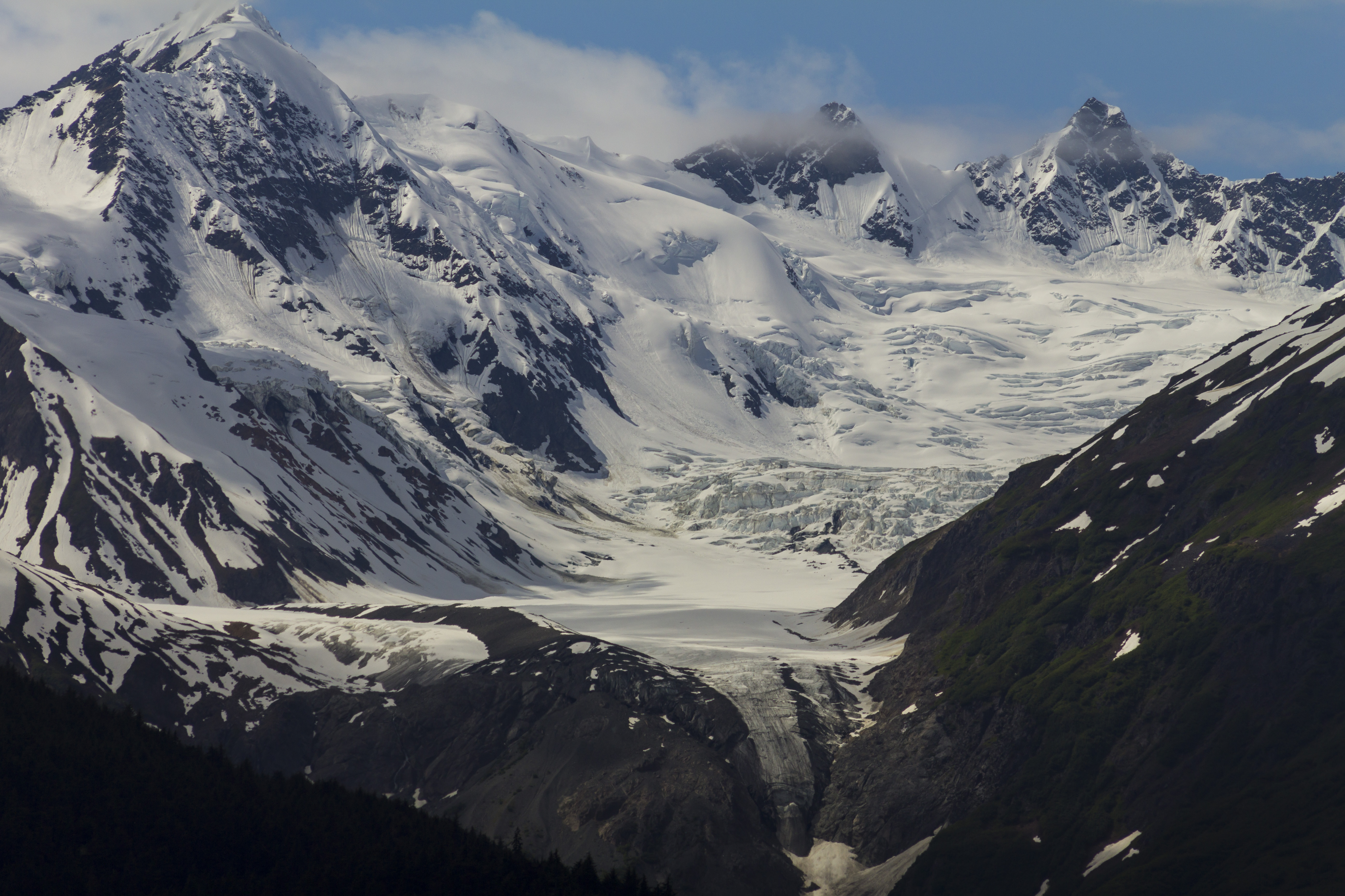
Heading up the highway, I spy magnificent views of the peaks of the upper Chilkat and Boundary ranges. The Jarvis Glacier comes to view and I marvel at it’s presence. The clouds have parted just enough to cast an epic nature on the scene unfolding.
I feel blessed, and the underlying nature of these mountains and glaciers become me once again. Summer is unfolding and the Bear and the Salmon are just now emerging in an unstoppable and exponential fashion. It is a glorious time of year in Alaska…
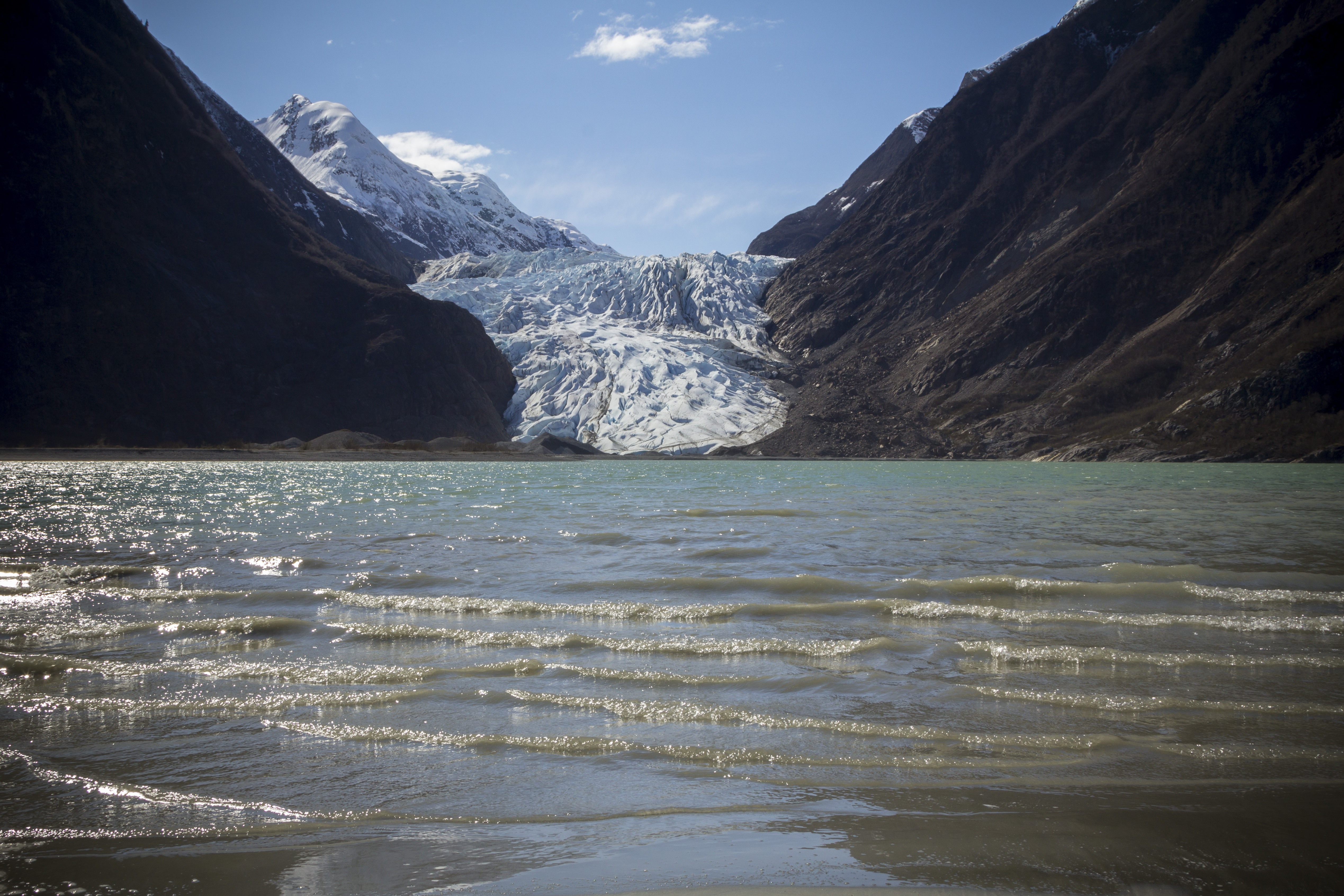
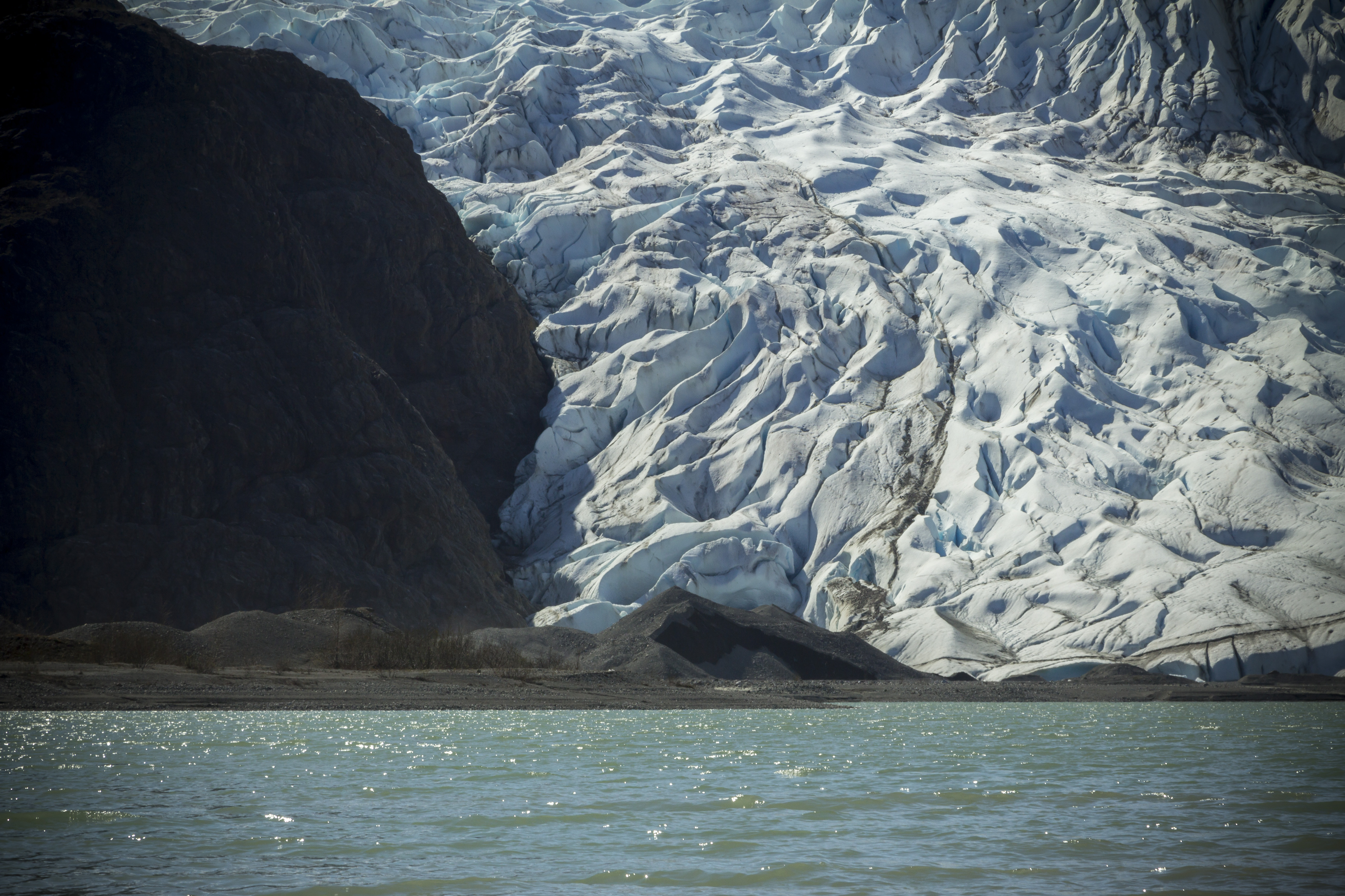
Fine spring weather and a weekend off urges me to pack up the skiff for a first -time-this-year-sailing. The 12 foot Lund has some leaky rivets, and the 39 year old Johnson 9.9 horse motor is about as decrepit as they come. Still, it was time to get out across the water and explore. I pack the boat and call Angela to roust her from whatever she was planning for the day, and soon we are humming along in dead calm ocean water; headed for the opposite side of the Chilkat Inlet to explore the Davidson Glacier and the areas around Glacier Point. We spot River Otters, Sea Lions, and Humpback Whales along the way. The weather is the sort you dream of in Haines: sunny and partly cloudy skies, warm temperatures, and not even a wisp of wind. Soon we are beached on the shores of Glacier Point, and before we can get camera gear into backpacks for a trek up to the glacier, we spot a Humpback whale surfacing and spouting it’s blow hole. Within seconds the creature is back in the depths and without notice, the Humpy has breached the water and is airborne. Our jaws drop, and we expect it to end there. Over the next 5 minutes or so, the Humpback breaches and spins and tail swats airborne style at least 10 more times, causing great and rewarding splashes. We are in awe of the spectacle we have just witnessed. I have never seen anything like it, not even close. I was so riveted by the performance, I refused to grab the camera for some action video. My dinky 105mm lens likely would have produced unsavory results anyhow. As it was, I’m certain I got much more out of the experience with out the camera in my hand. As much as I want so bad that great shot, I want the experience even more.
Soon we are trudging up the dirt access road to the Davidson Glacier where we marvel at the beauty of the magnificent and engaging ice, as well as admiring spectacular views of Mt Sinclair and Mt Elba and the bulk of the heavily glaciated Alaskan Coast Range visible north of Juneau. On the way back we find a flock of twenty strong Snow Geese nestled into the coastal grasses of the surf plane, catching up on some well earned rest.
That night, the wind picks up and we are thankful we had decided to pitch the tent after all. In the morning, we see the storm clouds a brewing and the wind picking up even further. A quick escape is in order, and soon the boat is packed and we struggle to get the tiny skiff past the swelling surf and into deeper water where we can fire her up. Soon the motor is running and we hightail it back up the inlet, punching the small vessel through the two to three foot swells. This feels like survival boating and Angela is wearing the only life preserver we have. For fear of capsizing the boat, I stay on the decaying throttle to keep the craft moving directy into the oncoming surf. I am white knuckled, cold, and concerned. After a bit, Letnikof Cove appears and soon we are pulling up to the boat ramp and loading the truck. The storm never actually took foot, but it sure made for some big waves in a little boat.


Spring time in the Chilkat Valley is an impressive time. Seems the whole of the world is coming alive and staying busy with fattening up after a (not so) long winter. As I was pulling out of my driveway yesterday, a Sow Moose and her very large yearling were clambering down Cemetery Hill on Mud Bay Rd, headed right for my house. Animals, after a long absence, are emerging from the forest, and can be seen nearly anywhere If your eyes and heart are open to it.
After a six day work week, I am tired, but ready to get out into the real world of forest and river and animal; to have a peek and to get myself right with the world again. I head out around 9:30 Sunday morning and drive north up the Haines Highway. It is raining slightly, but it is not a bother to me. I want to head to a place at 25 mile I know of to look for and to shoot video of Moose. I drive slowly and in a manner of no hurry what so ever. Eyes peeled left, I see an animal on the shores of the only inches deep Chilkat. It appears at first to be a Lynx, but as it turns, I see that it is either a young and lone Wolf, or more than likely, a large Coyote. I pull off the road and the animal drops what it is eating and scrambles up the far embankment. Not wishing to disturb the creature’s fine and tasty meal, I too scramble back onto the road way and wish the Canine farewell. I get to the mudslide area at 19 mile and look out over the sandy river braids and spy two Eagles in a tree top. Between them is a nest the size of my pickup bed. They appear to be guarding it, and once again, I leave them in peace.
After a bit I am nearing the place I want to go, but realize after crossing the Chilkat bridge, there is far too much snow for my two wheel drive truck to handle on the dirt road leading back to the area in question. Reluctantly, I turn around and head back down valley, moving as slowly as before thinking the right place will pop up. At 18 mile, I turn into a pull out and descend into the bushes and thickets leading to the innards of the forest. Camera and tripod are heavy, but I figure it would be worth it to get a shot. Good and sellable clips are rarely placed in front of you, at least when it comes to animals, although I do know some folks with homes situated as to have their own private wild animal zoo in their backyards. I am happy to be thrashing into this forest however. Soon I am on a game trail and Moose dropping appear, though hard to say how old they are. I hear a creek ahead, and I stumble upon what is quite obviously a major Bear/Salmon area, The shores of the creek are heavily trampled, and lying about are many lower jaw bones of last years run. The area is so heavily used looking, I can imagine this place has been a Bear feeding ground for untold centuries. This place is a treasure, and I continue on, contemplating how dangerous it might be in a few short months when the fish are spawning again and the Brown Bears are out feasting. Back at the truck, I head down valley and spot, on the other side of the river, fifteen to twenty Canada Geese on a layover in a massive field. Further out, a moose is grazing peacefully. Having only my Xtra Tuff’s on, I swear to myself I will always carry my hip waders in the back of the truck. I drive through town and down the peninsula, where there are perhaps eight or nine Eagles feasting on the Sleeper Shark that washed ashore last week. On the drive home, I pull off to watch an Otter bobbing it’s head as it swims parallel to the shore in search of fish.
Sure is a spectacular time of year here in Haines…never got even one single shot. Didn’t matter.
Living at nearly 60 degrees north latitude is an interesting experience in regards to the seasonal changes and the Earth’s placement in the solar system as it rotates around the sun. Prudhoe Bay on the Alaska’s north slope is exasperated even more so, but even here in Haines, at a little over 59 degrees north latitude, one really notices a significant change in the length of the days starting in March; we now have nearly 14 hours of daylight, and the sun is gaining elevation in the sky daily. The midnight sun is approaching and soon the Bears will exit their den’s and the Salmon will begin to run. It is a glorious time of year in this neck of the woods…

A paragraph from the book I just can’t seem to actually finish… maybe that is the point; maybe it is not supposed to be finished…
“Just south of the lodge known as Bell II, I look through a clearing in the forest and see for the first time Canada’s great and glaciated Coast Range. Craggy peaks engulfed in ice and nary a road any where near them, I feel a washing aesthetic come over me, similar to seeing for the first time in many years the Canadian Rockies weeks earlier. I am coming home to a place I have never been, and a heartache for all things wild and free develops within, and a budding sense of realism penetrates all that this pedal north is becoming. Thoughts of my past life in Moab are becoming a distant memory, with visions of the North encompassing all of me and all I will become. This place, the Cassiar, her mighty rivers and expansive forest, begin to feel oddly familiar. There is a vague yet noticeable tinge of something ancient in these forests; something unexplainable that has catapult me into a womb of wilderness and animals. I see a Black Bear, then another, then another. The concepts of the modern world drifting from my heart; the destruction I feel I have left behind, the crying of a world gone mad, and the never ending forest are all I see now. In retrospect, I am quite certain that it was at this point my life changed forever. Never again could I be satisfied or feel safe in a world full of madness and decay. Here, my heart lost in a sea of timber and mountains, I see nothing but balance and I could never again return to what I had left behind. I was still a long way from Alaska, and if what I was experiencing here was only a precursor, I felt I might simply explode when I arrived in what the Athabascan’s call, “The Great Land”.”
The following piece was written, uploaded, deleted, and uploaded again. It is a work-in-progress
Also, If you want to get the most from JRB, and really want to read the stuff I put on here, don’t just wait for it to be posted on facebook; SUBSCRIBE!
You can do this by pushing the “follow” button to the left and entering your email address. In fact, at some point very soon, I will stop posting JRB to Facebook altogether. Just Rolling By needs to be it’s own entity, not something that is read because folks see it scrolling mindlessly through Facebook…
QUESTION ALL THAT YOU HAVE BEEN TAUGHT
One of the things that is perpetually on my mind these days as so many more before, is the notion of modern life. Seems we have become an article of economics, and the conceptual hows and how nots of the best and most fullfilling way in which to live one’s life upon the ever deepening demeanor of modern civilization. As Thoreau wrote, “What you get by achieving your goals is not as important as what you become by achieving your goals.” This has always rung true with me, long before reading for the first time “Civil Disobediance”. I remember not so long ago, on a long distance bicycle journey throughg Alaska’s Arctic that there seems a disconnect between who we have become and who we really are. Since childhood, I have been dumbfounded by concepts of material possesion, and the means to support the idea at large, versus the the path that we all must take to achieve personal happiness, and how it might affect the world as a whole and who we are in relationship to the planet. Too many people’s happiness and well being seem rooted in the degredation of planetary and community health. This is a tricky one, this notion, and it begs those who might follow a deeper and more compelling path of what might be considered “true” happiness, to re-consider what is really at stake. Thus, there are questions that seem to ride on my shoulder on a daily, hell. hourly basis: What do we as a species require to be fullfilled? What are the underlying needs that we all have to feel safe, happy, and socially connected? Without damaging what most in our arcane and insane culture has led us to believe? My belief is that we have created a society that has empowered nonsense and belittled growth and sincerity.
How can one feel deeply satisfied with the concepts of the modern work “ethic”, paying for and endowing to banks, lending institutions, schools, social security, IRA’s, stock investments, real estate ventures, medicare, health insurance, car insurance, licensing fees, building permits, taxes, mortgages, rent, internet access, cell phone coverage, fuel costs, vehicle maintenence, hospital bills, pollution, environmentral rape, social ignorance, chemical dependance, pornography, corruption, crime, false religion, bureaucracy, and the general bastardization of a society that we have allowed to be run by those of a moraly corrupt disposition? It is total and complete nonsense to me.
I wish to live a relatively simple life. One that is mostly free from government intervention, one that is free from scrutiny of the status quo, one that is aimed at health of self and surroundings, one that rely on a community that rspects itself and those who are in need, and the only way that this can be achieved, in my very small and humble view, is to gain what is lacking. What I speak of is a concept that would eliminate all politics, law enforcement, voting, religion, crime, dependance, and corruption of all kinds. This is a concept, unfortunately, of a radical nature, one that the human world has never , ever seen before. Ever. Religion and politics pretend to teach it, the under payed teachers of our youth pretend to convey it, and the government claims they have it, But none do. Without it, the human world will self destruct and those not prepared will suffer. The human condition seems to be fueled by greed and control.
There is only one true answer to the accelerating demise of this decrepit civilization. Personal Responsibility. That’s it. It is that simple. I see it lacking in every aspect of modern culture and it is destroying us. However, it sure is giving some well paying jobs to priests, politicians, welfare workers, doctors, lawyers, and law makers.
If you don’t have this basic, required trait, GET IT. if you don’t, you are old news and will be left behind.
OK, E-nuff… off to have an adventure or two.
The following Story, “A Closer Look” was published this last fall in a fantastic collection of stories entitled, “Adventure at High Risk: Stories From Around The Globe”
After waiting an obligatory 3 or 4 months since it’s release, I am now publishing said piece to Just Rolling By for my readers to check out.
I am currently writing a novel sized book on the entire journey.
Hope you like it…
A Closer Look
By Linus Lawrence Platt
I first fell in love with Alaska when I was 15. Having grown up in California, Alaska seemed as far away and as wild as any place on Earth. I’d heard of this land when I was even younger, perhaps at age 8 or 9, when my father and his brother decided to drive to the Great White North to “check it out.” My Dad and Uncle never made it to Alaska, but the notion that it was an endless wilderness full of giant mountains, feral people, and wild animals, was born into my young mind. When I was 15, as a young neophyte climber, I read as many books about mountaineering and rock climbing as I could; these books spoke of far away places and far away ideas that left deep impressions on me. One such book was Art Davidson’s “Minus 148”, a tale of the ground-breaking, first winter ascent of Denali. It was this read that left on me an ironed-in impression of Alaska.
Over the years, as mountaineering became less and less important to me, I began to realize that my desires to be in the wild places that climbing afforded, was as important as ever. Being in the mountains was paramount, and climbing was a mere vehicle. Early on in life, I developed a love affair with bicycles and the notion of traveling long distances on one appealed to me, in the same manner that expedition mountaineering appealed to me in earlier years. So in the summer of ’93, I set out from Utah and pedaled to San Francisco, via Idaho and Oregon. This journey demonstrated all that I desired: to be self sufficient on a long, physical trip; one that allowed an element of adventure while traveling through high country and mountains. It was an eye opener for what might be possible; and somewhere, in the back of my mind, revelatory ideas about wilderness and ways to travel through it, began to hatch. I do believe it was on this trip, that I began to see and feel something greater in the world than just the routine of human life; to understand a deeper connection to all things wild and free and to appreciate the fact that we, as humans, were actually a part of this great wildness — and not separate from it. In late April 2011, I set out, from my home in Moab, Utah, on my bicycle — bound for Alaska.
It was a terrible winter that year, with record snowfall in many northern areas, and unusually low temperatures. I travel north, through Utah and into Wyoming, all the while feeling overwhelming joy that such a trip had finally started. I enter a different world as I pedal into Montana. No longer in the high desert of the past 1000 miles, I cross a threshold into the beginning’s of the Earth’s great boreal forests; forests that do not stop ’till high above the Arctic Circle, 3300 miles to the north.
I travel on, into British Columbia, and climb into the Canadian Rockies; I enter Alberta, the scene of many past climbing memories with people from another time and place. It was magnificent to see, after all these years, the Ice Fields, and all of her adjoining peaks and glaciers; this time armed not with ice axe, but with bicycle. The wheels turn, and soon I witness the vast boreal plateau of central British Columbia; I see more Black Bears than I can count. I roll through Smithers B.C. and marvel at this place, surrounded by glaciers and mighty, salmon filled rivers. Tribal elders and native fisherman tell me stories of long winters and their anticipation of the upcoming Moose Hunt. Alas, on June 9th, I cross the Skeena River and turn onto the mysterious Cassiar Highway. This road is a westerly alternative to the far more popular Alaska Highway in northern B.C., and gifts mountain scenery and remoteness. My first night on the Cassiar, I pull into an open area and spot a dead Grizzly; shot, I presume. I am too fatigued from pedaling a full day of rain to search out another camp. I am gripped by my short lived, but intense paranoia of the bears and sleep with one eye open. Over the next eight days, I witness some of the most remote and incredible scenery visible from a road in North America; fantastic glaciated peaks, bear, moose, eagles, rivers, and lakes. This natural balance I see before me brings tears to my eyes, and I think hard on where the human race is heading — and why. Rain falls like it will never stop. Spinning through this much rain . . . this many miles . . . this many hours, instigates bizarre things within my mind. I take a hard look at myself and the world around me.
Days later, past Whitehorse, I flow into the Kluane Range, the guardian front range to the mighty St Elias. Out of these mountains, flow the some of the largest glaciers in the Western Hemisphere. I journey on, around Kluane Lake, the Yukon’s largest; and once beyond it, the ecosystem changes yet again, and I see the first of many Black Spruce Taiga Forest, the hallmark of the True North. On June 27th, 2011, 59 days after leaving Moab — I enter Alaska.
An Alaskan native once told me, in jest, that the Pacific Northwest of the lower 48, was “a desert”. On this day, upon penetrating the Alaskan border, a rain begins to fall that is everything that man inferred. And for the next five days, that’s indeed what it does — with no end in sight. The setting up and taking down of the tent, the moisture consuming my sleeping bag, and the inability to keep or get anything dry, begins to take it’s toll on me. Worst of all, now nearing the Alaska Range, the storm obscures views of the peaks I came so far to see. I turn south on the Richardson Highway and the clouds part and for the first time in what seems like eternity, the sun bares brightly and the glaciers of the Central Alaska Range shine deep within me.
I learn, from a woman in Delta Junction, that a narrow two-track would lead, some fifty miles south, into an area known as Rainbow Ridge, and that an excursion there would reward me with access to the Canwell Glacier and the lesser, but enormously beautiful peaks of the Eastern Alaska Range. After some time scouting, I spy the two-track, and head off into the innards of the Alaska I really desire to see. I ride and push the bike back far from the highway, perhaps eight or nine miles, until I come to the lateral moraine of the glacier. I camp perched atop the moraine, overlooking the ice. I am home. The next day, as fine as the one prior, I embark on a scramble up a nearby granite peak, surrounded by nameless glaciers and tundra. The sensation of this magical place sinks into me, and there is no turning back.
A day later I enter the Denali Highway, 135 miles of dirt road traversing some of the finest wilderness in North America, in which I slow down, breath deeply, and take it all in. I spend four days out there marveling at the grand peaks of Mt Hayes, Hess, and Deborah, eventually turning south on the Park’s Highway and heading toward Talkeetna and Anchorage. As I move south, I feel civilization creeping in on me. I know that the part of this journey to encompass supreme wilderness is nearing closure.
I had pedaled over 3800 miles, and on August 9th, I board the Marine Vessel Columbia for a trip down the whimsical Inside Passage, ending port at Bellingham, Washington. I spend the next two weeks pedaling down the west coast’s of Washington, Oregon, and California. This is another world to me; cars, traffic lights, cities, towns, and difficult camp spots, at least in comparison to Alaska, where I could easily push my bike into any section of woods and have my own palace for the evening. Within the cities of central California, I feel trapped and overwhelmed; I long for the quiet and solitude that Alaska affords. After 4700 miles, this trip is over with a quickness. What I really want is to get back to Alaska and spend less time getting there, and more time being there. I crave a closer look.
Settling down in Sacramento for the winter to visit family and earn money for my return to Alaska was in order. The unfortunate event of having my bicycle stolen the following spring, just one month prior to my planned departure date, thwarted all that I had worked toward and my dreams of returning that summer shattered. I kept my head up and pushed on, hanging tough through the next 12 months and creating a tight and sound itinerary for the following summer; I developed an acute taste for the Yukon during this time, and wanted to see more of it. The following May, I drive my pickup to Bellingham, park at a friend’s house, and board another Marine Vessel, this time heading north to Skagway, Alaska.
The first day I face the biggest climb of the entire trip; from sea level at Skagway to the summit of 2864 foot White Pass at the B.C. border. I offload the ship, and dive into the dragon’s mouth. By dusk, I make the pass and have my tent set up in time to witness the alpenglow cover the glaciers to the east. It is may 20th, 2013 and it feels surreal to be back, as if I never left, but merely awakened from a long dreamy nap. I pedal up the Klondike Highway, passing through Whitehorse and embarking on many side trips down old mining roads in search of beautiful campsites, old cabins, wild rivers, grizzly bears, and eagles. I find all of these things in the Yukon and much, much more. About 2 days south of Dawson City, I spot a large mammal up ahead on the shoulder; I slow down and approach cautiously. At first, I take it to be a small Black Bear, but it doesn’t move like a bear; It dances and darts in a way that tells me only one thing — Wolf. As I move closer, it sees me and flies into the brush; as I move past, I can still see it’s legs behind the shrubbery, moving laterally with me. I stop. The Wolf stops. I move and the Wolf darts back out, into sight. We stop. We lock eyes. I am mesmerized by this magnificent animal; It appears to be an older wolf, perhaps lone; his coat, thick from a recent cold winter; his color nearly solid black. We tire of this staring contest and and in a flash, the wolf is gone. The next day, I spot a large Grizzly on a nearby ridge, digging for food. It is far away, but it’s motion and heft clearly demonstrate it’s kind.
In 2011, I had developed a hunger to visit the Arctic. To me, the Arctic represents the last bastion of real wilderness left on the planet; it is a place that few travel, and it is a place that, for all of it’s supreme ruggedness, remains one of the most fragile places on earth. I imagined it to be one of the most beautiful as well. I had to get there. I roll into Dawson City, centerpiece for the historical mining heralds of the Yukon, past and present. It is May 28th, which meant that it is still very early in the season for travel into regions of the Dempster Highway, but not impossible. If I am to embark on a trip up the 500 miles of dirt road on the Dempster, there might be weather and road conditions that are not favorable. But to me, it seems perfect. After spending a day in Dawson, I decide the only way to do this stretch is to do it round trip; 1000 miles total. The Dempster ends at the village of Inuvik, Northwest Territories, where one can buy food and supplies, but the two villages on the way are situated along the road as to make carrying the necessary food impractical. To alleviate this matter, I box up 4 days worth of food and leave it at the Dempster Interpretive Center in hopes that a traveler might pick it up and take it to Eagle plains, some 300 miles to the north. I spend the day gathering the remainder of supplies for a venture into a fantastic arena of mountains and arctic plains. In the morning, I pedal the 25 miles to the start of the Dempster and am pinned down by a several hour rainstorm that began calm enough, but was soon a torrential flood of monstrous proportions. I hole up at a defunct gas station at the junction of said road, and eat and drink to pass the time. Over the next two days, I cross the Tombstone Mountains and into the Blackstone uplands, famous for it’s crossing of the mighty Porcupine Caribou Herd, which, during it’s migration through the region, numbers in the high thousands. Passing the continental divide, the terrain is of an alpine nature of which I am most happy. From here, all water from these mountains flow to the Mackenzie River, and ultimately, the Arctic Ocean. More rain comes and I dive into the Engineer Creek Campground, which is still closed for the season; the place is deserted. It has a screened in cook hut and a luxurious evening was to be had. The following morning, I cross the Ogilvie River, and see the unfortunate sign ahead. “Road Closed”. A road worker chases me down after I sneak past the closure in hopes of somehow working myself and my bicycle around whatever obstacle lie ahead. The road worker says:
“Can’t you read?”
“Yes Sir, I can read just fine”, I say.
As I attempt to keep pedaling, he whips his truck in front of me and informs me that NO ONE will pass through here.
“The River has changed course from flooding and has taken out the road. Go back to Engineer Creek and hole up there ’till I send word you can continue.”
Reluctantly, I turn around, head back to the campground, and down the last couple of beers I had stashed. In the morning, a truck pulls in and some folks from Washington inform me they have heard that it will be several days before the situation is rectified. I felt sunk. I don’t have enough food to stay here sitting and waiting. They offer me a ride the 130 miles back to Dawson and I sheepishly accept. That night in Dawson, I wrestle my thoughts: Had I made the right decision? Could I have stretched the food I had? I put it all behind me and went to bed, hoping I wouldn’t be discovered, camped illegally on the outskirts of town. After breaking camp, I board the ferry across the omnipotent Yukon River, and commit myself to what’s known as the “Top of the World” highway; a hundred or so miles of gravel traversing the hilly, sub arctic dome country of the western Yukon and eastern Alaska. The monotony of the endless forest and the ever growing number of hills are putting a hurt on me, but I manage to get across the Alaska border the next day.
More rain ensues; more spectacular scenery begins to appear. Great, wild rivers in the areas surrounding this stretch of the Taylor Highway begin to cheer me up, and soon the Dempster/Top of the World episode is behind me. Near the junction of the Taylor and Alaska Highways, about 30 miles from Tok, I crest a hill, and as if on cue, the clouds part, and the sun shines down upon the ever magnificent Alaska Range. I feel, once again as if I’d come home. They appear almost himalayan in size and have the sensation, to me, of seeing an old friend. I spend a couple of nights in Tok, then pedal along the northern and eastern flats below the impending Alaska Range. The creeks are plentiful and crystal clear, and I drink copious amounts of water from them. Another night of thunderstorms and packing up in the rain today. It is getting to be routine; I am finding myself able to pack it in with my eyes closed. Later in the day when the sun is out, I pull out the tent fly and it dries while I snack.
In Delta Junction, I camp on the gravel beaches of the wildly braided Tanana River, looking to the south at the appearance the central Alaska Range’s Mt’s Deborah, Hayes, and Hess; all are visible. I have never seen the north side of these peaks; I decide to camp here in hopes of catching a time-lapse of these giants’ in the morning, with the sunlight splattered across their eastern escarpment and embellishing their glacial armor. The scene before me stirs my desires for reaching the Arctic again.
There are only two roads, in North America, that one might pilot a vehicle of some sort, leading to this continents Arctic area’s. The Yukon’s Dempster Highway, and the Dalton Highway, aka “The Haul Road”, in Alaska. Both of these paths are of the dirt and gravel variety. The Haul Road, remote indeed, was built in 1974 as a supply line to the north slope oil fields at the Arctic Ocean, and parallels the Trans-Alaska Pipe-Line, was not open to use by the general public until 1996. Up to that point, the truckers had it solely to themselves. The Haul Road traverses a rugged landscape north of Fairbanks and leads to Deadhorse, Alaska, crossing terrain varying from the forested hill and dome country beginning at Fairbanks, to Taiga swamps and open tundra, crosses many, many rivers and streams, and penetrates the “Alaskan Rockies”; the continental divide at the bastion of true roadless Alaskan wilderness: the venerable Brooks Range.
Saturday morning I gear up, and soon my bicycle is spinning north. The day is filled with some of the worst hill climbing I have ever encountered. Finally crossing Snowshoe Summit at the apex of Alaska’s White Mountains, I am rewarded with a long downhill and a stream of spring water shooting from a pipe near the road’s edge. The water is clear, cold, and delicious. Passing creeks and abandoned cabins, I look for a camp, and pull onto a dirt track next to the Tatalina River and dive into the water after setting up. I am then greeted by terrible swarms of Alaska’s famous insect.
The next day, more of the same hill climbing ensue, only worse this time. The hills are 12 to 14 percent, made up of loose, unconsolidated gravel, and the truck traffic is thick. This day turned to be the hardest of the entire road. By day’s end, I am so exhausted, I can do nothing but dismount the bike and push the dead beast upward and over the hilltops, coast down the other side and repeat. More big hills the following morning, lead, thankfully, to the Yukon River, where once across, the road flattens out a bit and some pristine forested Alaskan countryside sprouts up. Eventually, however, the hills re appear and the grind continues. After 70 miles, I find a gravel pit to call home on the fringe of Finger Mountain, 25 miles south of the Arctic Circle. The first bits of Arctic tundra, permafrost meltwater lakes, tors of granite, and windswept mountain passes are now within my eyesight. The next day, the landscape changes dramatically to the type of high country I so desire. After crossing the Arctic Circle, I penetrate a small mountain pass and catch my first glimpse of the mighty Brooks Range. I drop into the valley below, and am greeted with magnificent spruce forest, and creeks filled with 24 inch Grayling. There is drinking water everywhere, a far cry from the relative dryness of the last few days out of Fairbanks. This landscape is what I came here for… unparalleled high country filled with rivers, mountains, forest, and animals.
In the morning, I am excited to enter the Brooks Range. After a couple of hours pedaling through soaring scenery, I decide to get off Haul Road proper, and get onto the pipeline access road, which offers a bit more of the deep solitude that this unbelievable place offers. Eventually the road dead ends as the pipeline disappears underground, which dictates back tracking to the Haul Road a couple of miles. However, at it’s end, a spectacular campsite is to be had, on the Koyakuk, and facing a sunset view of the mighty southwest face of Sukakpak Mountain, an impressive chunk of limestone real estate. After swimming in the Koyakuk, I set up the camera for an evening time-lapse of Sukakpaks’ dramatic episode of color and changing light.
A fine morning follows, and 40 miles of dead flat, yet gorgeous scenery ensue. The river becomes heavily braided; the forest begins to thin out. Signs of a changing ecosystem; of a different stature, unfold. The weather begins to change too. Thunderclouds build, then unleash; I retreat under a bridge and watch the storm from beneath, sitting next to river ice pack still 36 inches thick, here on June 20th. A few short miles and I pass the final spruce tree in this part of North America. It is all tundra and the road begins to climb. Up I go; the road flattens once again onto the spectacular Chandalar Shelf, a couple of hundred square miles of flat tundra in the heart of the Brooks, just below the continental divide of Atigun Pass, Alaska’s Highest and most northerly road pass at 4800′. As I near Atigun’s summit, the storm once again decides to unleash it’s fury. High winds, sideways rain, and plummeting temperatures commence. I top out at 9:30 pm and find a patch of snow free tundra a ways off the road and pitch my tent right there on Atigun’s high point. Even with guying the tent, I still have to brace it from the inside to prevent the poles from snapping. Finally, the wind dies off and I drift to sleep, dreaming that night of being deeper into this range of magic mountains in the North, father in than I am now, traveling high valleys among Grizzly Bear and Caribou.
I awake to a deeply silent atmosphere of near whiteout conditions; it is eerily calm. I pack up, and descend the pass slightly to the shelf on the north side and stop for a hike up to a ridge. The tundra here is squat and is easily traveled upon. It is crowded with tiny wildflowers of all shapes and colors. I pass the remains of a young Caribou, probably taken by Wolves’. Farther up, I glimpse down great gully’s of rock towards a massive creek with outstanding waterfalls feeding it’s descent into the Atigun River and beyond to the Arctic Ocean. The peaks are mere 6000 footers, but are massive just the same. The Brooks is a dry region; however, there are a few small glaciers scattered in a couple of places in the Brooks, but not here. There are thin gully’s of snow descending from the rocky summits of these peaks, providing a striking contrast to their nearly black and orange coloring. Eventually, I descend back to the bike, and continue on, down Atigun Canyon, and onto the great Arctic Plains of the Alaska’s North Slope.
The next two days are flat tussock tundra, starkly beautiful, and swelling with my favorite insects. I still see no Bears, but, plenty of Fox and Caribou. Alas, I spot a herd of Musk Ox, twenty strong, pre-historic, ice age creatures of the North American Arctic; an iconic figure of strength and endurance in this vast, untamed arctic landscape.
The next day, rolling into Deadhorse, it is 28 degrees F, 40 MPH winds, but otherwise uneventful. Deadhorse is the center of North America’s largest oilfield, which stretches for over 70 miles to the west. After a fitful night’s sleep, I pedal out of town a couple of miles, lay the bike down, and put out my thumb… Later, after no success in hitching a ride, I catch an hour and a half flight to Fairbanks, where in a couple of weeks, my lover, friend, and companion, Angela, is to meet up with me where we will continue the last legs of this journey, together.
These long bicycle trips had, until this point, always been done solo. Angela coming aboard for this adventure was new territory for me. It will be a new and wonderful experience to share this monumental place with her; a tough and beautiful soul, she also shares a desire for all things wild and free, and is a lover of animals, mountains and lakes. She has never been to Alaska, and I will be proud to show her what I know of this endless, magical place. On the late night of August 2nd, Angela, driving my truck up from Bellingham, pulls into Fairbanks, and within 24 hours, we are ready to go; and Angela, now riding the bike that I rode on that first trip back in ’93, is out to prove that old bikes don’t really die. I painted it green some time back, just before giving it to her. She set forth about calling the machine “The Green Bastard”, named after Bubbles’ superhero character in the Canadian TV show, “Trailer Park Boys”, and off we went.
We leave Fairbanks at three in the afternoon on August 4th, and still manage to pedal 34 miles to a nice woods camp in the Nenana Hills. The forest is a splendid place to be as the past two weeks of being in Fairbanks had been wearing thin upon me. After a hearty supper and a victory cocktail, we fall into a deep sleep that only two tired yet happy people can achieve. Pedaling the next few days brings us to Nenana, Healy, and McKinley Park; the third day of which, a car, speeding up behind me, veers onto the shoulder and nearly kills me, inches away from my handlebars. That night at a peaceful lakeside camp just north of Cantwell, we watch as the sun sets behind the western rim and an alpenglow on the opposing peaks highlights a small herd of Dall Sheep, clinging wildly to the upper slopes. After entering the Alaska Range, we sail into Cantwell, beginning of the glorious Denali Highway, and entrance to some of the most fantastic scenery Alaska has to offer.
The Denali Highway, which I had pedaled two years before, was built in 1957 and for many years prior to the Parks Highway’s completion, was the only way to approach Denali National Park, hence it’s name. The road is 135 miles long and connects Cantwell to Paxson; 120 miles of that are dirt and gravel. The DH, as I call it, traverses the entire Central Alaska Range, crosses uncountable streams and rivers, features tundra, forest, mountains and lakes aplenty. It also has some of the best free range camping anywhere. It is a true mountain paradise. We roll out onto the welcome relief of the gravel and with the exception of the dust from occasional traffic, we sail smoothly along the grandiose Alaska Range, surrounded by tundra, taiga, and wilderness. We spy a two track leading into the forest and think there might be a reward at it’s end. We ride through beautiful forest and brush, spotting a large Bull Caribou along the way. After a mile or so, the forest thins and the road turns downward to gain the roaring river below. Here, at this transition, lie one of the most spectacular camp spots of our lives. It is an open view of all the big peaks of the range; Mt’s Hess, Hayes, Deborah, Geist, Balchen, and Shand. After recently reading David Robert’s “Deborah: A Wilderness Narrative”, I was especially happy to be witnessing this spectacular place again. In from of us are towering peaks encompassing one of the great wilderness regions on the continent. Watching the sun set upon this picture, with it’s hues of red and orange, mixed with the deep blue of the glacial spectacle in front of us, is a sight we will not soon forget.
The following morning it is raining; we commit to the mud, and soon the McClaren River Lodge comes around and we drop in for a beer and a snack. We leave the lodge during a brief interlude in the storm, and climb the thousand feet to the summit. We are exhausted and wet, and it’s raining solidly. We ride down the two track of the McClaren Summit trail, and throw down our nylon ghetto onto the soft and sopping tundra and dive into the tent. In the morning, it is still raining, but our spirits are high as we prepare for the last day on the DH. Cool temperatures and more rain bring us to the pavement 20 miles from Paxson and signaling the end of the highway. We stop at the Paxson Lodge for a spell and some dry time; the weather begins to abate, and as we leave, we are granted fine weather for a pedal down the Richardson in search of another fine Alaskan camp.
We awake the following morning to outstanding weather and an early start sends us down the Richardson Highway to the Gulkana river for an afternoon of bathing and river laundry. It feels good to be in the river, the sun overhead and our clothing, now clean, drying on the clothesline I have rigged. Unfortunately, the camp is very moist, and our clothing doesn’t dry till noon the following day, which puts us on the road late. It works for the best, as we roll into a fine camp early in the day. It is extraordinary; consisting of perfect, flat forest right next to a steep 300 foot embankment that drops to the mighty Copper River below; infested with Salmon and running ever so strong. It also sports unobstructed view of Mt’s Sanford, Drum, Wrangell, and the enormous Mt Blackburn, all encased in glacial ice, and piercing the deep blue, cloudless sky. To me, it is a camp to behold. The Wrangell Mountains are a special place to me; They are remote, and, according to some bush pilots’ I spoke with, the most beautiful place in all Alaska
We continue onward, down the Richardson, and turn in on the old Elliott cutoff; a dirt track leading for ten miles, to the hamlet of Kenny Lake, an area of rare Alaskan agriculture featuring, pigs, yaks, chickens, and pastures. We stock up on a thing or two at the tiny store, and continue on, en route to Chitina. We roll on through, eager to get ourselves established onto the dirt and gravel of the McCarthy Road, and away from the troublesome traffic. Crossing the Copper River Bridge, we are greeted with a fine, Alaskan sight; the confluence of the Copper and Chitina River’s, the Chugach Mountains to the south and the Wrangells to the North, and the dip netter’s, still pulling late season Red’s from the icy waters’. I catch fine glimpses of the enormeous Mt Blackburn, at 16,390’, the sixth highest peak in Alaska.
The McCarthy Road is blessed with many small creeks and rivers’, all crystal clears specimens, born of the ice and flowing to the Sea. There are fewer lakes, however. Angela feels at peace when she is swimming in a lake, so we are always keeping our eyes peeled for an opportunity to do so. Further up, Long Lake appears, and Angela declares the place her spiritual home. Unfortunately, we find no spot to camp on it’s shores, but a site within it’s view were to be had, with the best Loon calls I have ever heard. Even Salmon enter the lake to spawn and the resulting Bears can often be seen catching their lunch. The next day was a fine one, with perfect weather and a short pedal to McCarthy, we were rolling through town by noon. About a half mile before reaching the tiny village, one is greeted by a splendid sight; in front of us lie the Kennicott and the Root Glaciers, both giants and flowing from towering peaks. As the rivers of ice rise to it’s birth place above the firn line, an enormous ice fall shows itself, the “Staircase Icefall” as it is known, is a sea of jumbled and towering blocks and seracs, all destined to crumble and become a part of the valley glacier below.
We find McCarthy more than pleasing; a tiny town full of laid back folks, tourists, flight seers, bush pilots, and mountain folk. We buy a few groceries at the unexpected store, and chat with a some folks before departing to find a camp. A local tells us of a trail that leads to the toe of the Kennicott Glacier, and we head out. After getting temporarily lost, we find our way and are rewarded by a great field of gravel, ice, and water. The Kennicott’s tarn, the size of an Alaskan air strip, is under constant barrage from it’s gravel covered ice source just above, and great splashes can be heard every so often. We camp near the shores of the tarn and admire the unbelievable glacial view from our camp. Later, we hike out, away from the tent, to inspect bear prints Angels had spotted earlier.
A day of hiking is in order and we pedal up the road, past the historic Kennicott Copper Mine, once the largest copper operation in North America. Passing through the mine area, we continue on a deteriorating trail, park the bikes, and continue on foot. Five six or miles up valley, paralleling the Root Glacier we hike, where we find a place that looks reasonable to descend, and down we go, crawling across scree covered ice hills to reach the main body of ice. Angela has never been on a glacier before, and it had been a while since I had last been on one of this size. We step out onto the flat ice, well below the firn line, and small, but open crevasses appear. A giant Moulin is flowing wildly upon the giant’s back and we drink freely from it’s source. We ascend back up the loose scree to the trail and skedattle down valley to our bikes. A quick blast back to McCarthy takes only minutes and soon we are in camp again. That night, very late, I get up and a slight tinge of the Aurora Borealis was beginning to appear. Summer was coming to an end.
The day following is Angela’s birthday, and it is raining badly. We take cover in the local coffee shack and put off getting into the mud till past noon. The day is spent mostly in wet conditions and endless, grinding, mud. This signals the end of my bottom bracket, rear hub, and drivetrain. My bicycle is very tired indeed. The next few days are spent pedaling south on the Richardson Highway, crossing the fantastic Thompson Pass, en route to Valdez, where we catch the ferry to Whittier and pedal to Anchorage. Angela and I say our goodbyes, which is hard since I will not see her again for five months, as I am staying the winter in Alaska. She boards a plane bound for the “outside”, as Alaskans are sometimes fond of calling the lower 48, and I, catching a rare and outstanding view of Denali from The Glenn Highway, shift back into gear, and pedal north, in search of another fine Alaskan camp.
“The more I see as I sit here among the rocks, the more I wonder about what I am not seeing.” ― Richard Proenneke
The untold tales of paths trodden, fears conquered and battles won.
tracking inner and outer landscapes along the road to creating community
Adventures starting in the heart of Alaska
...A Life Simplified Is A Life Fully Lived
More than just a Summer in Alaska
Indulge- Travel, Adventure, & New Experiences
News and opinions on the environment in the Haines area and greater North.
Exploring and Photographing the Alaska Range
The Adventures of a Man, His Heart, and His Bike
Mapping the bicycle travel revolution.
Just another WordPress.com site
A fine WordPress.com site
Just another WordPress.com site
Since 1999
Iowa City ~ (319) 338-8900

You must be logged in to post a comment.