A Dance With The White Princess

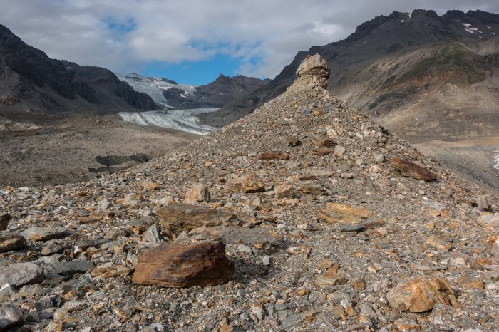
It had been raining now for days in Delta Junction, and I felt that we might be close to wearing out our welcome at the Delta Public Library and at the coffee lounge at the IGA food market, if for nothing else than for simply being; loitering as it were. I figured the troopers would show at any moment to arrest us for vagrancy. Of course that is just me being sarcastic, as Alaska in general, and this part of Alaska specifically is certainly a place where one can do as they please without vexation from others. Folks here respect individuality and personal rights and property. In fact, we had been camped along the Delta River on the outskirts of town for a long spell now. Our tents and some belongings left there daily as we meander around town and take up space at the library. This practice has resulted in absolutely zero harassment, theft, damage, or chaos of any kind. One of the many, many reasons I am proud to call Alaska my home. Some years back I had been camped on this same river beach on a long bicycle journey, and as I eat my lunch and listen to the rippling river, gun shots are heard alarmingly close. I look back toward the tree line at rivers edge and see a man leaned across the hood of his truck, pistol in hand and firing again. This time a great cloud of dust and debris explode not 20 feet from my position and I realize that either his is shooting at me (and is a terrible aim), or he is not shooting at me but does not see me. I assume the latter and scream at him. He looks more surprised than I do and screams back a shaken apology and gets in his trucks and skedaddles fast. Another time on this same beach, on yet another long bicycle journey, I had lost an envelope containing some 4000 dollars in cash. No shit… not stolen… lost. This beach has always been a strange yet somehow beckoning place to me… I simply can’t explain it, but I always like camping here when I am in the area. We had been killing time here for several days and except for a jaunt up Donnelly Dome during a brief, hours long lull in the storm, we had become a fixture in this tiny Alaskan town. The foray up Donnelly was a pleasant and rewarding surprise: as soon we pull into the parking area off the dirt road south of Delta about 20 miles, a massive Bull Moose trots past us, not 30 feet away and paying not the slightest bit of attention to either Dennis nor I and our dropped and gaping jaws. Donnelly’s summit, a mere 2500 feet above the surrounding tundra sports some arresting views of the countryside below, and were it not stormy, I’m sure the views of the Alaska Range some 40 miles to the south would have been nothing short of incredibly spectacular. At the summit, a Marmot skull sits upon a small stone, as if to peer southward to the omnipotent Alaska Range. Was it an omen? Was the creature’s skull a sign of imminent death in those magnificent mountains. I thought not and held the little critter’s head piece in my hand for a bit before setting it back down and retreating to the truck. Later in Delta, a weather report brings a light ray of hope in our little world and we hit the sack and prep for another mountain adventure to the south.


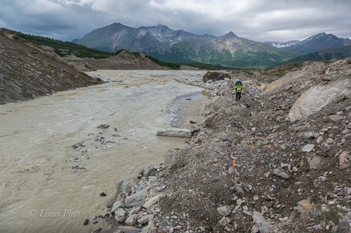
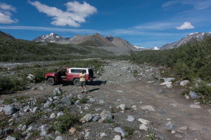
In the morning, I awake to a stillness and warmth that has been absent these last days; I peer from my tent to see a crystalline sky of deep blue and a calm that follows it. Walking out onto the beach, the central range has a clarity to it not seen yet on this trip: the massive peaks of Mt Hayes, Shand, Moffit, Balchen, and Deborah rise from the tundra with intent and sharpness, with not a wisp of mist or cloud surrounding their stature. The summits and ridges are sharp and full of contrast and color. This is a rare sight in these parts and I shout to Dennis in his tent of the spectacle. Soon we are up, packed, and off to our favorite diner for a celebratory omelette and endless cups of coffee. After a relaxing breakfast, there is nothin left to do but to begin the hour drive south on the Richardson Highway to the little 4WD dirt road I had discovered weeks earlier and the beginning of our hike onto the Castner Glacier and our goal deep within these mysterious mountains. We gas up and head south. On the drive down, a tourist has stopped at the bottom of a long full speed hill with a long lens poking from the vehicle’s window, shooting photos of a Moose foraging in a roadside pond. He is stopped squarely in the middle of the road in a high speed section and I pass doing 60 leaning on the horn. Soon we are at the dirt road, and the Toyota crawling along slowly, bouncing from rock to rock, emerges at the rough path and ends at the beginning of a faint game trail with the treacherous and thunderous Castner Creek roaring past with violence and intensity.

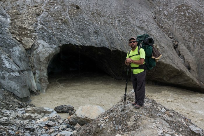
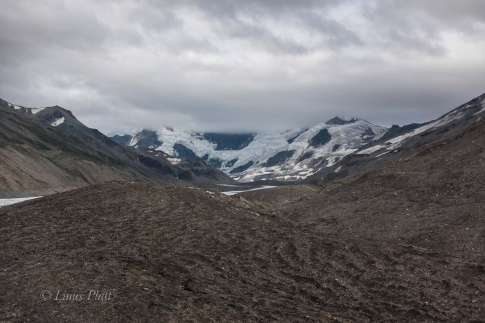
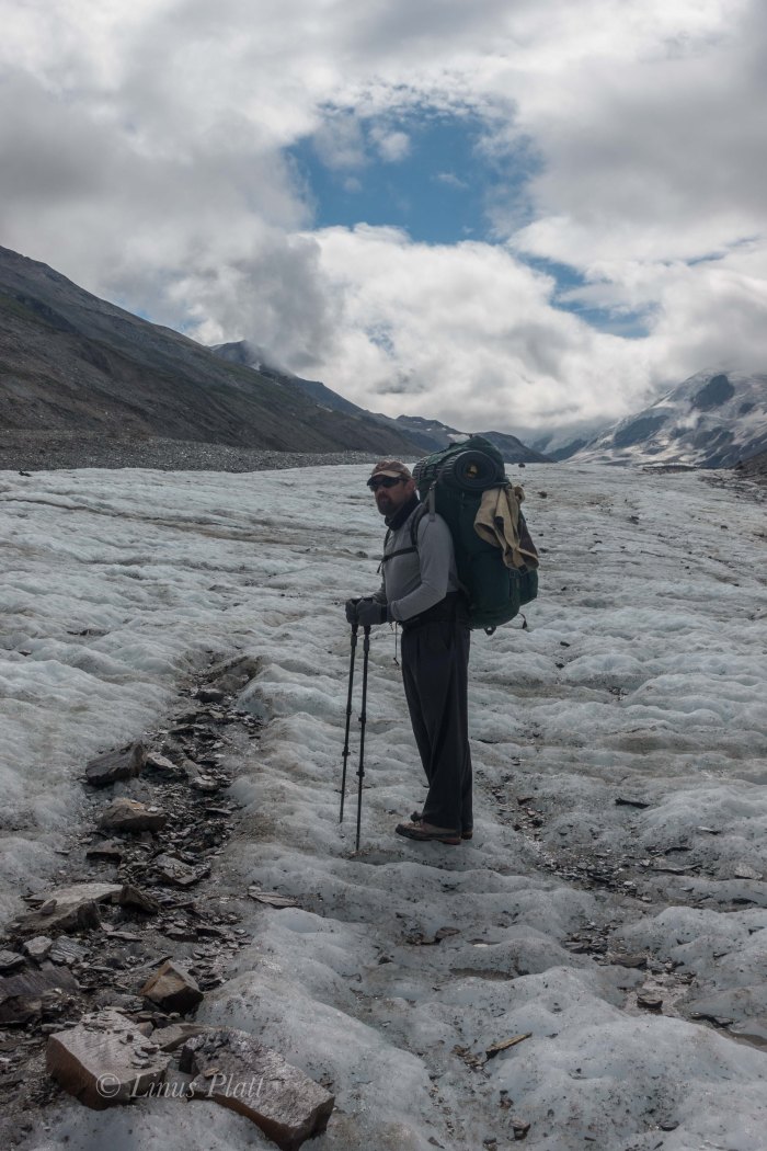
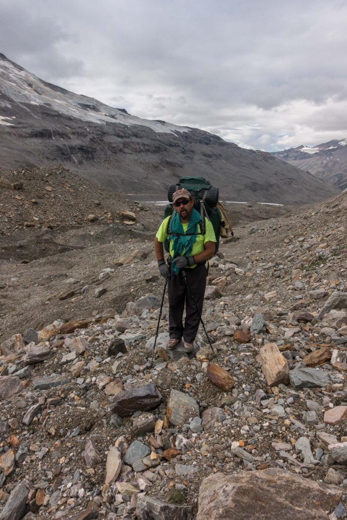
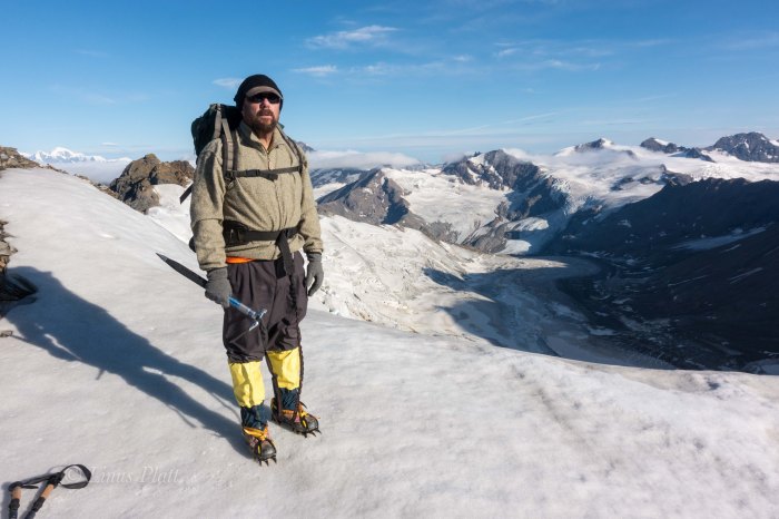
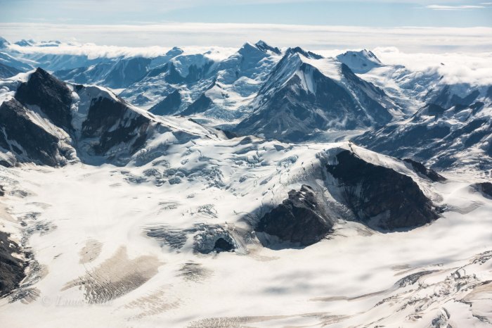
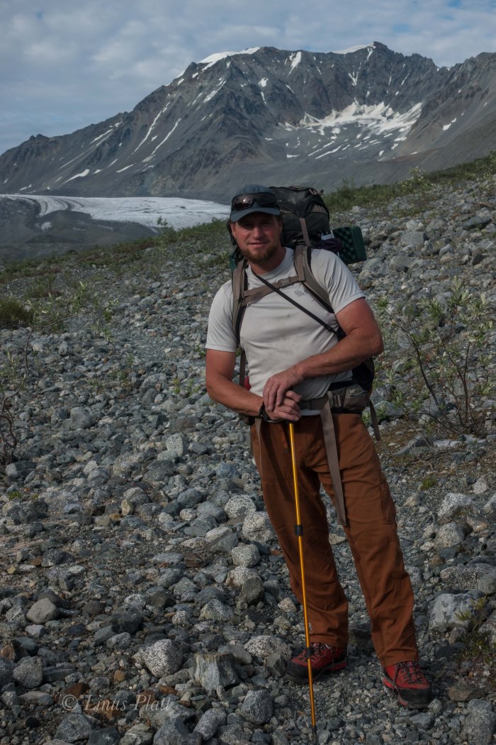
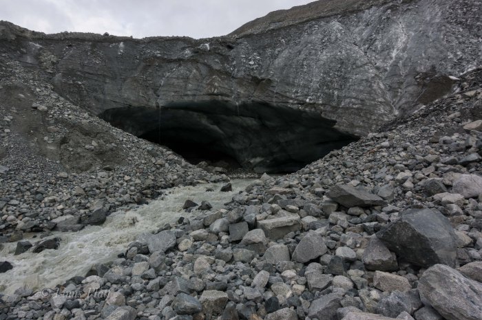
Our goal on this adventure is a peak known as the White Princess; a striking glaciated triangular peak of 9,800 feet, and one of the highest in the Delta Mountains. Descending from the summit of it’s 4000 foot west face are two distinct ridges, the Northwest Ridge and the Southwest Ridge. Our goal of the Northwest Ridge sits above a fork of the Castner Glacier called the M’Ladies fork, called so due to it’s origins from the cirque below the neighboring M’Ladies Mountain. After studying the maps purchased from the UAF in Fairbanks, and after reading scant accounts on the internet, it appears that our goal is to head up the Castner for about 8 miles to where the Castner splits into three separate forks, all leading to different cirques and several different peaks. From the fork in the glacier, another three or so miles up the M’Ladies Branch will take us to the base of our route. The first mile is flat and pleasant and meanders the Castner Creek corridor to the toe of the glacier, where a massive ice cave penetrates the snout of the beast and from it spits out the raging river beside us. A short scramble up the scree and mud to it’s left brings us to the top of the moraine and the debris covered serpent we will be traveling for many miles ahead.

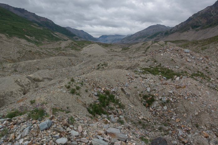
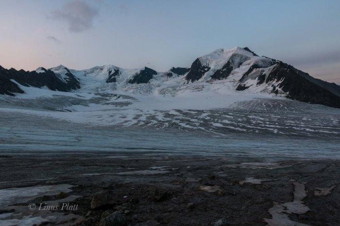
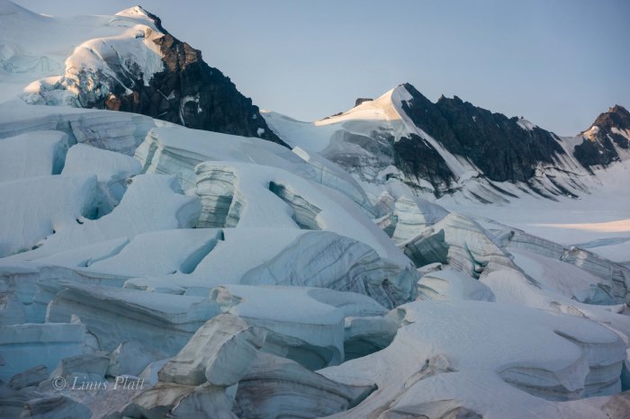
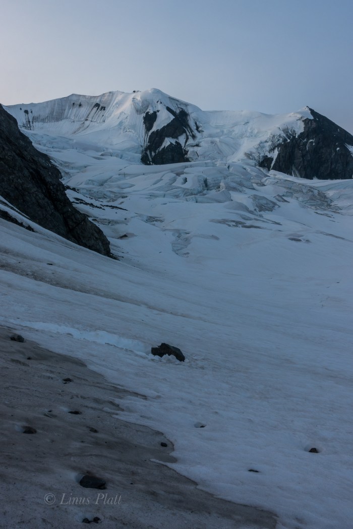
After breaking through the Alder thicket near the top of the moraine, we are greeted with a sobering sight. Now, I am no stranger to traveling upon debris covered glaciers, full of scree, talus, medial moraines, crevasses, and moulins, but what lay ahead was another matter all together. For as far as the eye could see, all the way back to the M’Ladies Branch, lie what can only be described as an endless field of unstable talus, mud, Alder thickets, and boulders. I have never seen a glacier so entombed in such a disastrous array of debris and ankle busting madness… for miles. It becomes clear that the Castner is a big, dying glacier that has become entrenched in more chaos than I thought possible. All accounts I had read were all done in the earlier months; meaning most trips into this region have been done on skiis, allowing relatively sane passage along this corridor and into the high cirques, but we were here in July. The thought of endless mile after mile of this sort of blistering travel filled me with dread. However, what must be done must be done, and the beginnings of a very long day of tedious route finding, side hilling loose scree, and heinous bushwhacking through Alder and Willow thickets ensues. After navigating the initial moraine and figuring out a path of least resistance, we emerge on the far right side of the glacier/moraine where dense thickets are growing. Off to the right of these thickets, steep mud slopes lead far below to the emerging ice and it is at this delicate spine that we must adhere to in order to make this trek feasible. Hours of meandering the Willows and mud fields brings us to more open areas where the glacier is obviously now just below the surface of this undulating and heaving mass of mud, Willows, and scree. A small ridge is gained and we stick to it’s intent; the sides of which peel off to both sides to ice caves and mud fields. Eventually we come to where we are high enough on the glacier to where it is now simply a matter of traveling monotonous talus and it feels a welcome relief.  Miles from the truck, and hours later, we emerge at the fork in the glacier, where we find exhaustion and fatigue taking it’s toll and decide to make a bivi.

Glacial moraines are not always the most forgiving places to sleep, resulting in some time spent clearing areas out for our bivi sacks by moving the razor sharp rocks and layering them appropriately into level and reasonably comfortable slumber platforms. Once this was accomplished, supper was prepared and we eagerly crawled into our sleeping bags just as the evening alpenglow engulfed the imposing North Face of M’Ladies Mountain and the un-named peaks to the south. It was a lovely sight for my eyes as I drifted into much needed sleep. I dream that night of Dall Sheep and glaciers…

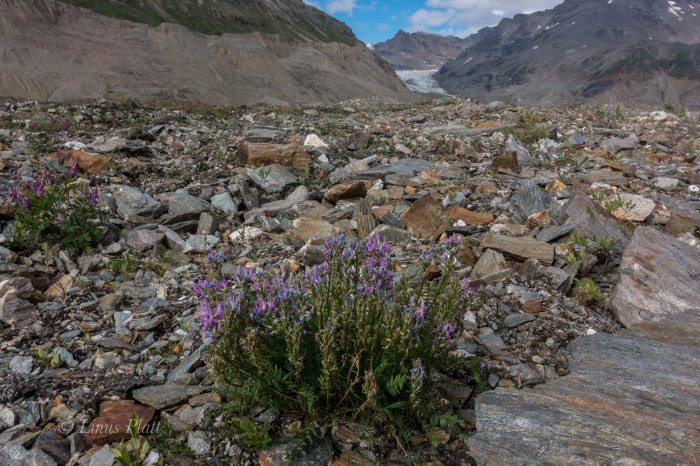
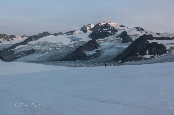
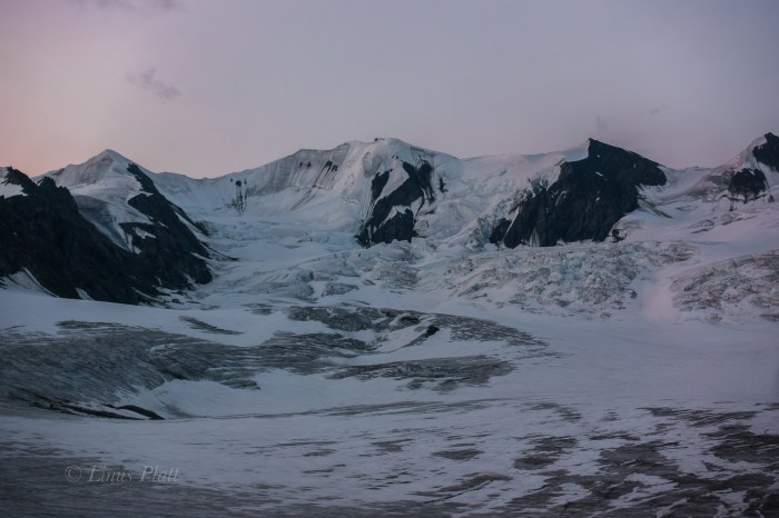
The morning we sleep somewhat late since we are under no pressure to get going early, as the 3 miles of glacier travel in front of us to move our bivi to the base of the route should only take a few scant hours. This feels luxurious and after a relaxing breakfast, we are moving back onto the ice; the sky above filled with a mixture of blue and scattered clouds. The ice of the glacier crunching beneath our crampon-less boot soles and the swooshing of the many runnels of moulins flowing on the surface of the ice. Once in a while, one of these glacial rivers disappears into a “sink hole”, where the water travels to the bottom of the glacier to become a part of it’s ever growing subterranean river. Peering into these dark and bottomless holes is downright spooky; if one were to fall in, you would certainly be done for. Dennis suggests we set up a rope and rappel into one for photographic and filming purposes, but the thought of even entering one of these icy tombs frightens me endlessly. Being who I am, I feel always best when I am in the Alpine Zone, far above the tree line, high on a cliff, or on a mountain top. Tight places, caves, tunnels and whatnot have always been something I drastically avoid: my phobia of these places sometimes even invades my sleep. We continue up glacier and large boulders appear; marbled Schist ranging from a dull grey, to shining silver with great veins of quartz meandering through it, to swirls of bright orange and red, indicating there are a variety of minerals in these mountains.

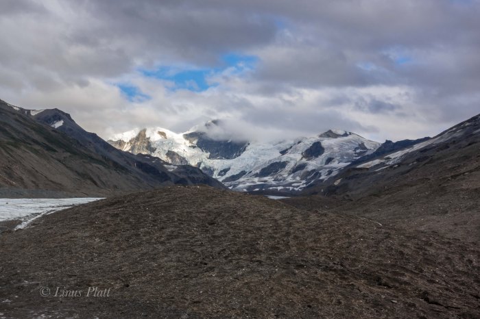
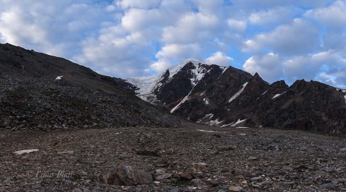
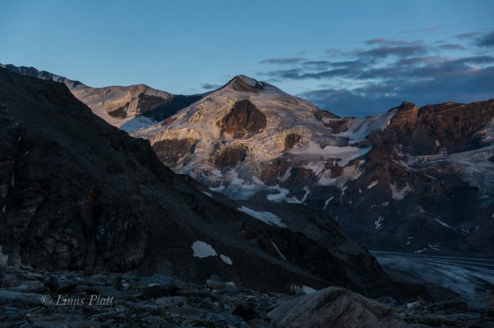
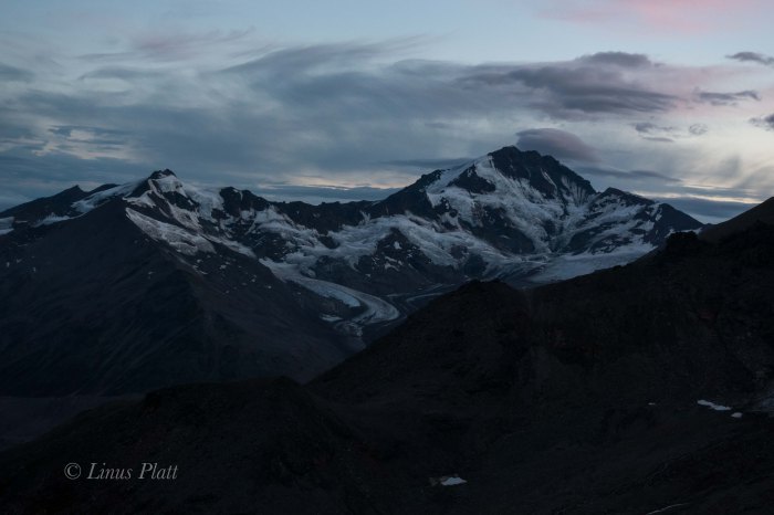
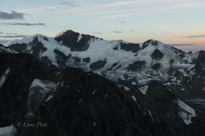
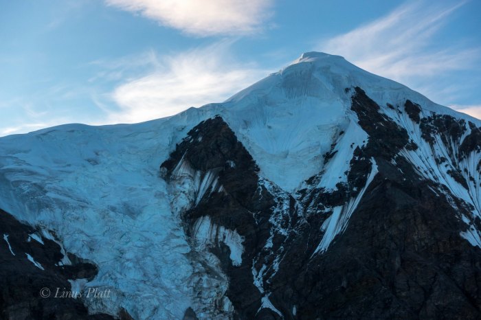
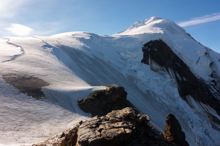
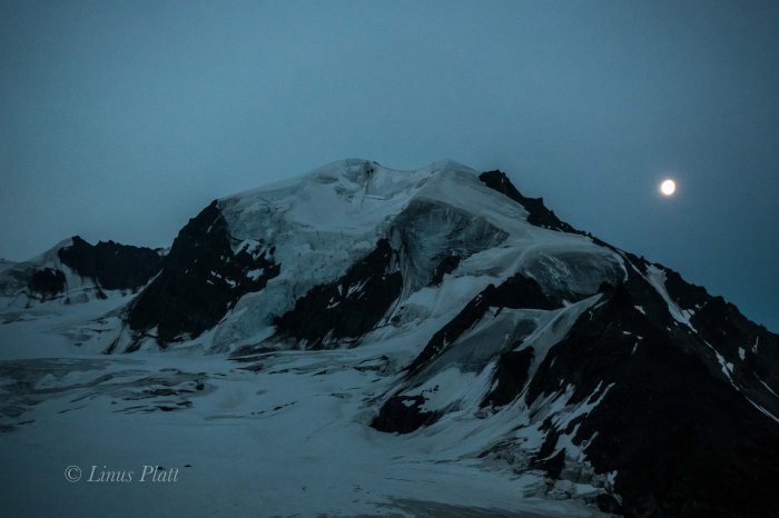
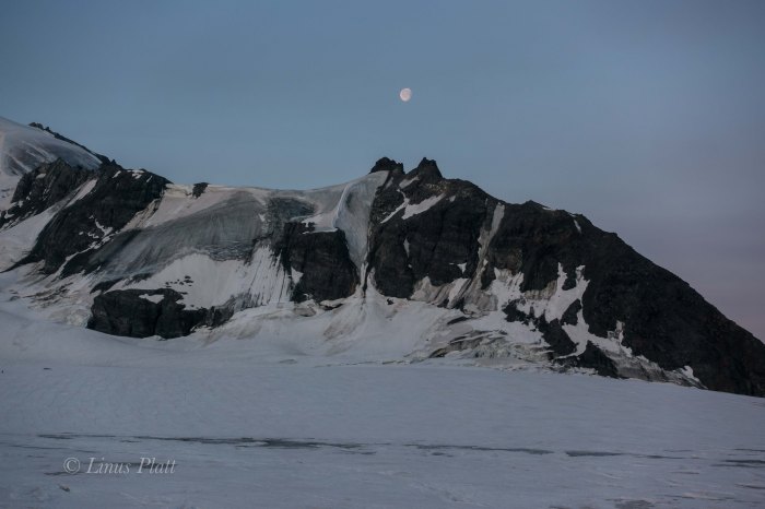
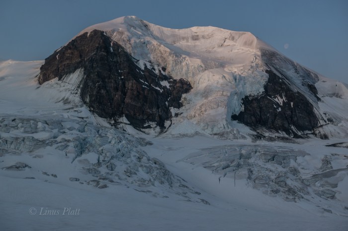
Soon, we come to where we are looking directly up at the western arm of the Northwest Ridge of the Princess; between the bottom of the ridge and where we now stand are great cliffs of shattered rock and an enormous waterfall cranking past the entrance to the upper valley where another large, but dying glacier flows from the Princess’s massive, if crumbling and treacherous West face. A desperate looking scree slope rises to the north of these menacing obstacles perhaps 500 feet to where there is green tundra and small alpine meadows. This, I’m thinking will be a splendid spot for our new bivi. Upwards to the scree finds us both clamoring foolishly; two feet up, one foot back, until at the nasty looseness culminates into an apex of sorts where what seems like class 5 scree leads directly to the lush and welcoming tundra. After some time scouting and going up another level higher to the base of the ridge proper, we find some level tundra and a small stream for water and call this home. Early to bed for a 3 am alpine start is in order; the weather is continuing to improve and after lying there in my bag wide awake for several hours, the sky clears completely, and one of the finest displays of Alaska midnight alpenglow I have ever witnessed takes hold. The giant peaks of the Hayes Range thirty miles on the other side of the Delta River Valley are immersed into the pink glowing alpine madness; the West Face of the White Princess shows a magnificent transformation that earlier appeared hideous and grotesque, now exhibiting a beauty and elegance that emphasized it’s massive hanging glacier and heavily crevassed summit pyramid. M’Ladies Mountain is not left out of the grandness either, nor is Mt Silvertip, Mt Blackcap, Triangle Peaks, or any of the countless un-named peaks in this region. The sight is incredible, but only adds to my sleeplessness, as I am compelled to shoot photos till after 1 am… the alarm will sound in just two hours.

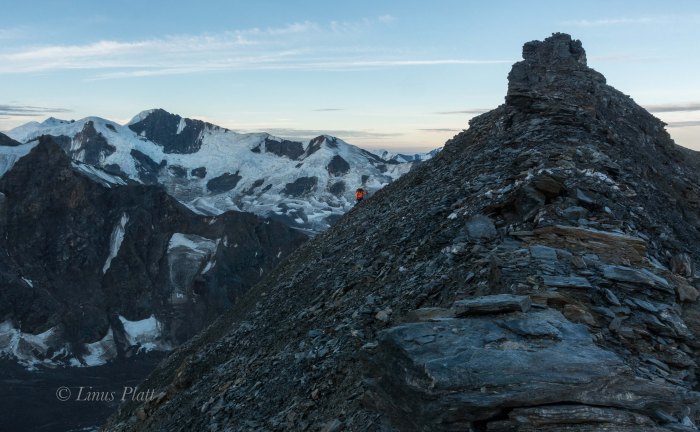
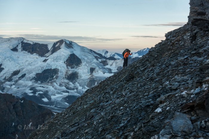
I drift to fitful sleep and what seemed a second later, the alarm goes off and I am up, shouting to Dennis at his bivi a couple hundred feet away that it is time to get a move on. After much time spent simply getting to a point where we can begin boiling water for tea and oatmeal, we finally do so and begin the trudge uphill beyond the tundra and into the seemingly endless talus towards the top of the lower ridge. It is already 4:30 am and it takes us another 2 hours just to reach the beginning of the exposed and treacherous looseness of the scree and mud knife edge that leads to one false summit after another.

Now one thing I know about alpine climbing is that in order to climb decent snow and ice, one must get out of camp at an extremely early hour. This means having one’s proverbial shit together for a lightning fast escape from camp after waking. For whatever reason, this did not happen on this morning and I felt we were on the route far later that to be desired; I knew the snow and ice conditions would be crap by the time we were upon them. Once to the ridge top, the sides dropped away to glaciers on either side; so steeply in fact that a fall here would be certain death under any circumstance. After each section, a small gendarme would have to be negotiated on one side or the other, and at other times, small summits would appear and endless loose talus would have to be climbed to go over it’s top, where we would then wistfully descend to yet another saddle, looking upwards toward yet another summit on the ridge. The last major summit to be climbed up and over was a big one and consisted of extremely loose scree and gained close to 900 feet of elevation, before descending it’s top and losing another 500. After this reluctant descent, we find ourselves deposited at the start of the ice and the first views into the hidden cirque containing the upper Castner Glacier, the NW Face of Blackcap, and a daunting set of sliver thin seracs clinging suspended like from the groaning and fractured ice below us. Directly underfoot lay the top of a great ice couloir; not far below it is a mighty bergshrund of epic proportions where darkness prevails just inside it’s frigid caverns. The couloir that lie below this fracture appears rock hard solid ice coated with a black film of sand and debris pitched back at an angle of about 70 degrees. Far below, perhaps 2000 feet, lay a field of steepening seracs and agonizing crevasses to reveal one of the more chaotic sections of glacier I had seen yet in this range.

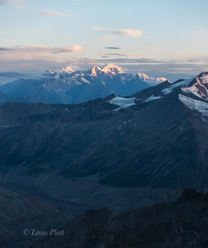
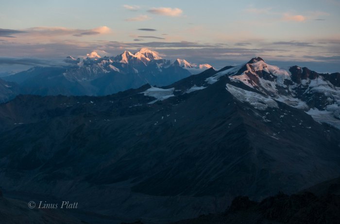
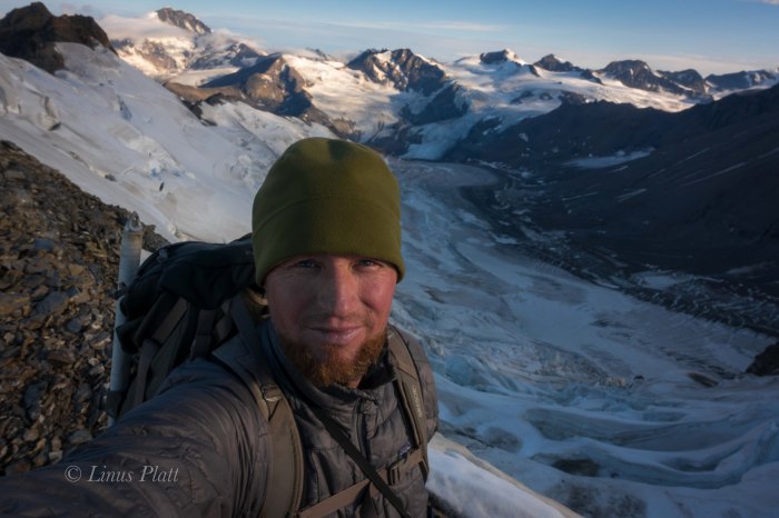
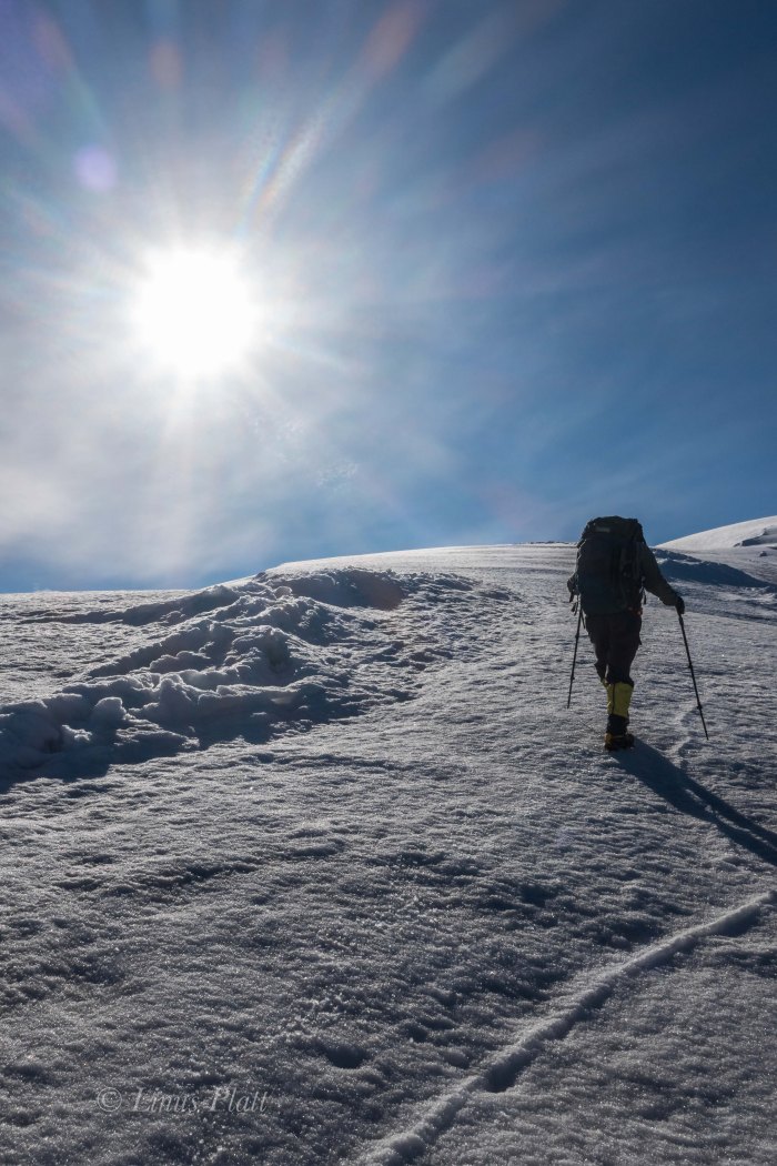
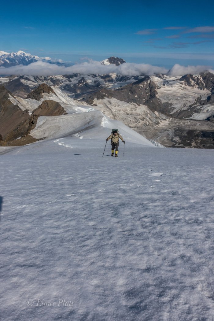
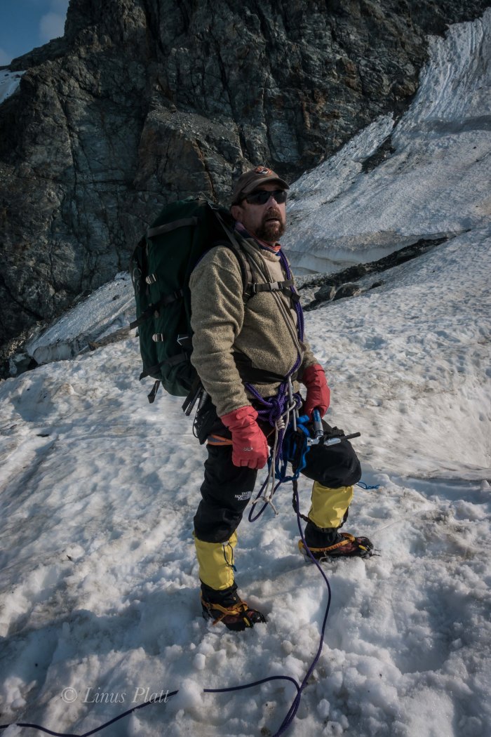
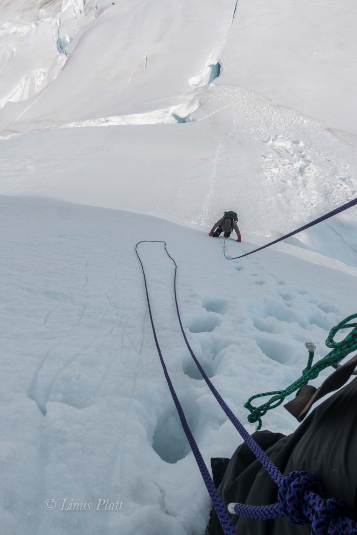
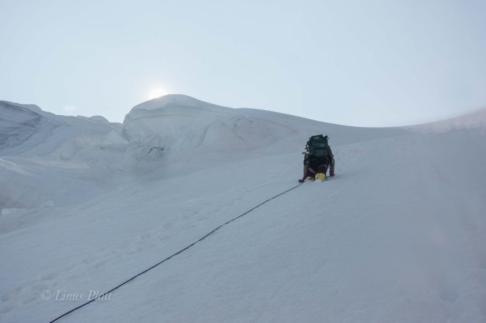
Donning crampons and axes, we front point above the lower ridge line to where a crevasse must be negotiated and a traverse to the far left brings us to more open views of the airy cirque below. The exposure is greater here as well and once across the icy gap, we find the ridge flattens to a long and even stretch of neve and crevasses that are mostly easy to spot an avoid. Still unroped, we climb a steeper 45-50 degree bit of nice firm neve for about 300 feet which places us at the beginning of yet another long crevasse field. After probing into this area and finding holes, we decide to rope up and work our way across this crevassed plateau towards the rising and dominant summit pyramid. A great cornice sticks out from the summit and avalanche debris can be seen on the slopes below, perhaps 500 feet from the top. Off to the right, a serac that we could see clearly from our bivi has peeled away from the main body of the glacier and hangs precariously over the staunches of the west face, threatening to drop the entire 4000 feet at any give time, in fact this whole area to our right is a time bomb of falling seracs and ice. As we move further upwards and getting closer to the pyramid, the hanging tongue of the glacier can now be seen up close before spilling over the side and into the bowling alley chutes of the audibly disintegrating west face. We had both heard the ice falling from this tongue last night; it would come in waves… almost in perfect rhythm. A crash, then silence… repeat. As we enter the crevasse field, the neve gives way to deepening snow and crevasses that are not only skimmed over lightly making for dangerous conditions, but are hard to spot as well. After a spell, the summit block is near and Dennis expresses his concern with the route I had chosen to climb it via it’s more direct western side. I mention that if he thinks we should climb the longer and easier looking east side, then I am OK with that. I ask Dennis to lead the way and off into the worsening snow conditions we go, aiming for the east ridge and it’s juncture with the summit area. It was getting colder the higher we climbed, but it was late morning now and the intensity of the sun was incredible. The snow was softening and endless amounts of sunscreen and glacier cream had to be applied; sunglasses were adorned more sternly and as we trudged into the deepening snow, crevasses began to be a bit of an issue as my leg poked into one… then another. Dennis too was poking through to have a peek into the glacier from time to time. We neared the upper east ridge and soon I could see up it’s spine toward the summit; what now became obvious was that the east ridge was a corniced knife edge and would require much more care than had previously thought. In fact, the climbing looked dangerous and time consuming. I declared that we must return and instead of descending the treacherous crevasse field to re-join our original line, took the lead and began an arduous traverse across the base of the summit pyramid, working my way through the avalanche debris we had seen earlier. The conditions continued to worsen and now instead of merely being a nuisance from post holing, it was now what I would certainly call breakable crust. If you put your weight uopn the snow and stepped up, it would hold you for a half second before giving way and sending your leg deep within, sometimes all the way to one’s crotch. To alleviate this madness, I developed a technique twhere instead of hoping the crust would hold, I would forcibly thrust my foot through it and stomp the snow beneath to hold my weight; usually this was no more than 12”-16” below the surface. It was far better than giving mercy to the crust and the velocity of one’s weight depositing your foot 36” under. By the time we got across the avalanche debris, we were beginning to climb the lower slopes of the summit block. We were both working terribly hard and in between the sounds of my own gasping, I hear Dennis cussing wildly and damning this place all to hell. Tensions build between us and all I can think of to say is that this is all a part of mountaineering, and listening to the bitching is making it harder. I put it out of my mind and soon we are at the lip of a large crevasse creating a steeper pitch to the summit ridge. We stop to re-group and set up a belay where I lead up and over the final obstacle; suddenly there is no more going up and all sides around us peel off in every direction. To the north the summits of Blackcap and Old Snowy rise from the surrounding icefields, and beyond lie the endless tundra to the north. The Hayes group off to the west appear Himalayan in size and block all views of the western range including Denali herself. To the south and east, the magnificent icefields and serpents twist and wind down rarely seen corridors leading to rarely visited rivers and deep wilderness. The north faces of some of the visible peaks are nothing short of spectacular; there is a sea of ice before us. Most of these ice entombed peaks are un-named and rarely climbed and the sense of isolation here is somehow unexpected, yet glorious. These peaks of the Eastern Range are small compared to their western counterparts, but are ever omnipotent in their own right and absolutely command respect; this place, these peaks, the glaciers below us touch my heart in a way that makes me feel both very small, yet very big as my place on this planet reveals itself to be an important one and the unexplainable beauty of this place sinks into me so deeply it can never be extracted. I love Alaska and it’s mountain ranges, it’s animals and people, it’s wilderness, and endless possibilities. There is simply no other place like it.

After consuming calories and taking some photos, Dennis and I shake hands in celebration and descend the summit pyramid; the task is almost as difficult as the ascent was, but soon we are out of the treacherous snow conditions and happily cramponing somewhat firmer neve utilizing french technique and front pointing down the steeper sections to the ridge, where more crevasse negotiation takes place before we come to a place where 3000 feet of scree lead off the south side of the ridge to the glacier below. We opt for this alternate descent so that the endless gendarmes and false summits may be avoided all together, but this is an unknown route down, and I am a little apprehensive. After considering the alternative, I jump off the ridge and commit to the scree. After descending several hundred feet, I wave to Dennis and he commits to scree as well. Some of this stuff is small enough and loose enough that one can actually “ski” down it; boot soles kicking off tiny avalanches of ball bearing rocks and then attempting to stay on it’s surface. The technique works surprisingly well, and after about an hour, I am near the ice not far below. I wait for Dennis for a bit and when he arrives he says he wishes to traverse to a shelf off to the right as he believes it will lead back to our bivouac. I feel that descending to the glacier and stomping it’s length is a better alternative, so Dennis and I part ways for the remainder of the descent. Pretty soon, Dennis is out of sight and I am trudging along the muddy scattered surface of the glacier below the west face of the White Princess. Looking up, I see the littered path of the constant icefall heard the night before; the ice gullies and chutes a debris field for exploding ice chunks and rockfall, I figure it to be suicide to attempt to climb this face. In camp by 4:30 pm, I spot a mother Dall and her two babies on the edge of our bivi, but there is no sign of Dennis. I am too tired to eat and crawl into my sleeping bag and fall asleep almost instantly. Later, I awake to Dennis’ footsteps. We chat for a bit before he stumbles off to find his own sleeping bag to caress. Sometime later, I feel raindrops on my face and dig into my bivi sack deeper for cover. Sleep takes me completely and when I awake, it is 5 am and raining.

We decide that hanging out in our bivi sacks for the weather to improve sounded like a torturous idea; not only that, but my ankle injury from two years previous was flaring up; it was time to get out, but the thought of the death march back to the truck was daunting to say the very least. I downright dreaded  it. The initial scree slopes from our bivi down to the glacier were painfully slow and detrimental to my ankle, but soon the glacier appears and we are making headway down to the fork. After 8 hours of battling this beast, I make it back to the truck. Dennis is somewhere behind me, and I decide to bath in the icy cold Castner Creek, make a sandwich, and take a nap. Two hours later, Dennis comes rolling in and we fire up the “Yota and head north for Delta, where more sandwiches, a six pack of beer, and a glorious sunset over the Alaska Range impresses upon us a time for relaxation and deep sleep. The next morning, we casually head back to Fairbanks, where Dennis’ previous foot injury and my ankle injury are needing rest. Dennis fly’s back to California a day or so later, and I rest up for more unknown solo adventure and begin to think about heading south a bit, for in another 10 days, I will be meeting Angela in the Yukon for a climb up Mt Archibald in the Kluane region… but that’s another story.

White Princess-Delta Mountains-2
Dennis at the end of the rough dirt road at Castner Creek
White Princess-Delta Mountains-3
Linus just before starting the “Death March”
White Princess-Delta Mountains-4
The raging Castner Creek
White Princess-Delta Mountains-5
The ice cave from which Castner Creek is born at the toe of the Castner Glacier
White Princess-Delta Mountains-6
Dennis nearing the toe of the Castner Glacier
White Princess-Delta Mountains-7
Linus at the snout of the Castner Glacier
White Princess-Delta Mountains-8
Dennis at the snout of the Castner Glacier
White Princess-Delta Mountains-9
The beginning of the Death March up the Castner
White Princess-Delta Mountains-10
Beautiful exposed ice caves along the way
White Princess-Delta Mountains-11
Endless scree, talus, and Willow
White Princess-Delta Mountains-12
Willow thickets separating the lower and upper sections of the approach
White Princess-Delta Mountains-13
Getting higher on the glacier

White Princess-Delta Mountains-14

White Princess-Delta Mountains-15
Taking a break near the M’Ladies Branch
White Princess-Delta Mountains-16
Colorful boulders and high moraines
White Princess-Delta Mountains-17
The Broken Glacier… now buried under debris
White Princess-Delta Mountains-18
Interesting moraine features nearing the M’Ladies Branch
White Princess-Delta Mountains-19
The Castner’s medial moraine and the M’Ladies branch forking off to the right.
White Princess-Delta Mountains-20
Debris covered ice at the fork
White Princess-Delta Mountains-21
Looking up towards the main Castner fork
White Princess-Delta Mountains-22
Our first view of the lower face on M’Ladies Mountain
White Princess-Delta Mountains-23
Marbled Schist
White Princess-Delta Mountains-24
M’Ladies showing herself
White Princess-Delta Mountains-25
M’Ladies Branch bivi
White Princess-Delta Mountains-26
Linus at the bivi after the Death March
White Princess-Delta Mountains-27
Looking up the M’Ladies Branch of the Castner Glacier
White Princess-Delta Mountains-28
Dennis setting up his bivi
White Princess-Delta Mountains-29
Dennis Belillo… “Sure glad that Death March is over…”
White Princess-Delta Mountains-30
Evening light on M’Ladies


White Princess-Delta Mountains-31
Breakfast bivi

White Princess-Delta Mountains-32White Princess-Delta Mountains-33

White Princess-Delta Mountains-34
Finally on the ice…
White Princess-Delta Mountains-35
Looking up the Silvertip Branch of the Castner Glacier and the giant and complex Mt Silvertip
White Princess-Delta Mountains-36
The lower reaches of the East Face of Triangle Peak
White Princess-Delta Mountains-37
The waterfall and shattered cliffs guarding the upper valley below the West Face of the White Princess
White Princess-Delta Mountains-38
Dennis on the second day of the approach
White Princess-Delta Mountains-39
Nearing the bivi site and the West Face of White Princess

White Princess-Delta Mountains-40

White Princess-Delta Mountains-41
The second bivi
White Princess-Delta Mountains-42
A Dall Sheep inspects our bivi
White Princess-Delta Mountains-43
White Princess
White Princess-Delta Mountains-44
Traingle Peak
White Princess-Delta Mountains-45
Un-named Peak between M’Ladies and Triangle Peaks
White Princess-Delta Mountains-46
The NW Ridge of the White Princess follows the left skyline
White Princess-Delta Mountains-47
Mt Silvertip at 1 am
White Princess-Delta Mountains-48
The West Face of the White Princess and the NW Ridge on left

White Princess-Delta Mountains-49

White Princess-Delta Mountains-50
M’Ladies Mountain

White Princess-Delta Mountains-51White Princess-Delta Mountains-52

White Princess-Delta Mountains-53
The Hays Group, Central Alaska Range
White Princess-Delta Mountains-54
Dennis approaching one of several gendarmes
White Princess-Delta Mountains-55
Dennis nearing the top of the lower ridge

White Princess-Delta Mountains-56

White Princess-Delta Mountains-57
The lower section of the NW Ridge of the White Princess


White Princess-Delta Mountains-58
The hanging glacier and the upper part of the NW Ridge
White Princess-Delta Mountains-59
Looking down into the hidden cirque of the Upper Castner
White Princess-Delta Mountains-60
Mt Silvertip and the Hayes Group looming behind thirty plus miles off…
White Princess-Delta Mountains-61
The Upper Castner Glacier far below the NW Ridge
White Princess-Delta Mountains-62
Linus at the start of the upper NW Ridge of the White Princess
White Princess-Delta Mountains-63
Dennis really glad all that nasty scree is behind us…

White Princess-Delta Mountains-64

White Princess-Delta Mountains-65
The summit of the White Princess 2500 feet higher
White Princess-Delta Mountains-66
One of the level sections of the upper route
White Princess-Delta Mountains-67
The White Princess
White Princess-Delta Mountains-68
The beginning of steeper climbing
White Princess-Delta Mountains-69
Dennis on the lower part of the upper ridge
White Princess-Delta Mountains-70
The Hayes Group from the NW Ridge of the White Princess

White Princess-Delta Mountains-71White Princess-Delta Mountains-72White Princess-Delta Mountains-73White Princess-Delta Mountains-74White Princess-Delta Mountains-75White Princess-Delta Mountains-76

White Princess-Delta Mountains-77
Crevasses below the steep summit pyramid of the White Princess
White Princess-Delta Mountains-78
Blackcap Mountain
White Princess-Delta Mountains-79
Dennis traversing the avalanche slopes below the summit

White Princess-Delta Mountains-80White Princess-Delta Mountains-81


White Princess-Delta Mountains-82
Looking south from the summit
White Princess-Delta Mountains-83
Looking southeast from the summit of the White Princess
White Princess-Delta Mountains-84
Linus on the summit of the White Princess
White Princess-Delta Mountains-85
Dennis on the summit of the White Princess
White Princess-Delta Mountains-86
On the glacier below the West Face of the White Princess during the descent


White Princess-Delta Mountains-87
Back in Delta Junction after the White Princess with the alpenglow lighting up the central Alaska Range- Mt Hayes on the right

My Art Is For Sale

Selling stock video is always hit or miss… It provides a small supplemental income that I hope one day will blossom enough to allow me to stop building homes for a living and have more time for climbing, hiking, and biking adventures, exploration, and creativity such as film making and writing. SO, if you feel up to it, click on the link below and browse my footage and photos… Thank You!


Up next: The White Princess – An account of one of this summers climbing adventures!


https://www.pond5.com/stock-video-footage/1/artist%3Ajustrollingby.html#1/2063/artist:justrollingby


JustRollingBy Stock Video Portfolio

Icefall Peak: Building A Perspective

After leaving Haines and driving my thirty year old decrepit Toyota pickup across the Yukon to the Northwest Territories border, followed by penetrating the Alaskan Interior and riding my bicycle into the Wrangell Mountains by way of the splendid Nabesna Road, it was time to get down to some mountaineering. My old buddy Dennis from California was to meet me in Fairbanks on July 7th and after a day or two of re-grouping, planning, and getting the truck in order, we were off, heading south on the beautiful Richardson Highway bound for the Delta Mountains in the Eastern Alaska Range. The Delta’s are the most accessible and driest peaks in the Alaska Range and sit at it’s far eastern end in the rain shadow of the taller and more remote giants across the highway in the Hayes Range. Most of the peaks here are in the 8000 -10,000 foot range, moderate to heavily glaciated, and approaches are generally made from the Richardson Highway; however the eastern most peaks such as Mt Kimbal are approached via the Alaska Highway north of Tok and these approaches could be considered extreme, as in 40 miles up braided glacial rivers full of Alder thickets and Grizzly Bears. Our aim was to hike into an exceptionally easy area to access know as the Gulkana Group that is situated a few flat miles from the highway. In fact, from the Richardson, a 2 wheel drive dirt road leads to within a mile of the toe of the Gulkana Glacier.

Driving south from Fairbanks, we spot the central Alaska Range rising gloriously behind the Delta River and since this is Dennis’ first trip to Alaska, we pull of to gawk at these Himalayan sized (bulk, not height) peaks far to the south. Passing through Delta, we stop for gas and a cup of coffee before continuing south and into the spectacular scenery the next 70 miles has to offer; to me, it is one of the best places in all road accessible Alaska. It is an area just north of the Alaska Range, where tundra, Spruce and Aspen forest, creeks, rivers, and rising glacial peaks dominate the landscape. The incredible numbers of Moose and Caribou here is staggering. It is a blue bird sky today and as we approach Castner Creek near the toe of the Castner Glacier, the White Princess, a striking triangular ice clad peak pierces the deep blue and we stop for a gander through the binoculars, as it is one of our goals over the coming weeks. But today, we continue on to the Gulkana and our goal of climbing Icefall Peak, which at 7,772 feet would be considered minor at lesser latitudes, but at 62 degrees north latitude, it is of the heavily glaciated variety and carries beneath it a magnificent, if troubling set of broken and daunting seracs known as the Moore Icefall. The slightly lower peak to it’s south, an un-named peak called Peak 7,680’ on the map, is by far the most striking peak in the cirque, with a long and jagged hanging glacial tongue descending from it’s upper flanks down to it’s base in the bowels of the Moore Icefall, and beckons to be climbed. I had seen photos of it and not found any information on routes or description on either peak; such is mountaineering in Alaska, where many peaks are un-named, rarely climbed, and undocumented. It certainly adds to the remoteness and sense of adventure that being in these majestic mountains affords.

The old Toyota rattles up the dirt road perhaps 3 or 4 miles before petering out within a few hundred yards of a suspension foot bridge crossing Phelan Creek, allowing scientists, students, geologists, and climbers access across the small but raging glacial river and into the wide gravel valley beyond which accesses the tongue of the Gulkana Glacier itself. Due to it’s proximity to the road, the Gulkana Glacier area is a place of  much study from the University Of Alaska and it’s GeoPhysical Institution, the USGS, and scores of other scientists and geologists. The USGS even built a hut at the 5000’ level high in the cirque back in 1968, which has served as a haven for climbers and skiers ever since.

After spending a couple of hours getting our gear in order, we hit the trail and soon are delicately walking across the swaying suspension bridge just up river. On the other side, the trail climbs a short hill, then descends to the gravel basin beyond, where the trail meanders up valley for 1 or 2 miles, passing along the way a geologic gauging station, to the ice cave endowed snout of the Gulkana. We manage to get to the ice cave where we must make a choice: either cross the dreaded fury river in front of us, or climb up and over the massive cave via the endless talus and scree slopes above and traverse around it. Either way, we decide to make the decision in the morning and to make a bivi, but the last good flat spots are a half mile back, so reluctantly we head back down valley a bit to throw down our evening ghetto. That night, during the endless daylight, I hear crashing rock and icefall every so often, reminding me we are now in the real mountains and caution must be afforded. Coming to the ice cave once again in the morning, we decide that the safest way is to bypass the river by going up and over the cave from where the river flows. This circumnavigation leads to not only the toe of the Gulkana, but to another ice cave; this one is not blocking our way, but begs for exploration. I ask Dennis to join me, but he declines, so in I go alone. The ceiling is a deep blue color and scalloped smooth. It goes back a few hundred feet where I can see light… it is a beautiful example of a glacial ice cave and seems to connect with the cave that blocked us previously and the great and fearsome river can be heard erupting from it’s guts. After emerging from the cave, we are once again moving and soon on the tongue proper where a great moulin flows violently. We fill our water bottles and head upward on the debris covered glacier. Once the debris thins out, we are surprised to find that the bare ice is textured nicely with dirt and sand and that travel with out crampons is not only acceptable, but desirable.

A clouded mist forms above and just as the vast and colorful seracs of the Gabriel Icefall show themselves, the mist descends upon us to create a condition of somewhat eerie circumstance; the glacier is silent, the rocky moraines hidden, and visibility becomes low. We truck onward and soon crevasses begin to appear; all are easily zig zagged around, and as the firn line gets nearer, we begin to see the remains of snow bridges from winter, and soon the depths of the menacing cracks are skimmed over with dirty and forbidding snow.Luckily these obstacles are easily avoided, and once reaching the top of a steeper section of the glacier, the upper cirque opens up, yet visibility remains low. We continue to meander and zigzag around the maze of crevasses and looking up suddenly, I spot the USGS hut. The tiny A-frame structure sits atop a large moraine, perhaps 400 feet above the ice, and after another hour of crossing through the crevasse fields and climbing the talus we reach the hut and enter. The steep walls of the hut are a notebook for every climber and skier that has entered this cirque for the last 49 years. Every available space has been written upon. Tales of climbing, humor, and general chaotic nonsense fills these walls. It is entertaining to read these as we prepare our dinner. There is a plethora of food in the hut and decide to take advantage of a bag of military cuisine consisting of Mexican Chicken whatever… these single military pouches contain every aspect of a meal, from main course, to crackers, to dessert, and to coffee at the end, which we saved for morning. After supper, I step outside to see the weather worsening; it is beginning to rain. Let’s face it, in the Alpine Zone on a glacier, nothing feels nastier than rain. And so it is… raining.

Dennis, as I found out on a climb on Silverado Peak in the North Cascades a few years ago, snores terribly. For this reason, I cannot sleep within 150 feet of him. Not a chance… That sound goes right through earplugs. Dennis seems to like the confines of the hut, so I go out onto the moraine and pitch the tent. I crawl in just as the storm intensifies and most of that night was spent trying to keep the tent poles from snapping; Guying the tent out properly was something I got lazy with and was now paying the price. After a few hours bracing from the inside, I put on my parka and go outside to fix the problem by attaching more guy lines and stretching out to larger rocks nearby. That did the trick and soon I was able to drift into sleep. In the morning, the wind had died, but the storm was far from over, essentially eliminating possibility of climbing anything that day or advancing our camp any higher. After breakfast, Dennis and I go out to guy out my tenet even better. Then back to the dryness of the hut for reading some of my book “Shadows On The Koyukuk: An Alaskan Native’s Life Along The River”, the story of Sydney Huntington and his growing up on the Koyukuk River in the Brooks Range during the 1920’s and 30’s. The book is a pleasure to read and is full of vivid descriptions of a life and landscape that has mostly disappeared; one that during that period was indicative of the times. It’s a story of family and community, of hard work and strength, of hardship and survival, and of playfulness and joy. A damn good read. However, I tire of sitting in the hut and ask Dennis if he is interested in taking a trek across the upper glacier to inspect the ridge above us during a lull in the storm. He declines, so off I go alone, cramponing up the low angle ice of the upper lobe, in search of the ridge line and a view of the mighty Canwell Glacier below. It only takes about 30 minutes to gain the ridge and the view I was looking for revealed itself. The Canwell Glacier, 4 miles wide and maybe 20 miles long sits 2500 feet below me, is crevassed significantly, and splits into three branches just up valley, where more un-named peaks push from it’s jagged dormancy. I get some great views of the bigger peaks in the area before the storm intensifies, sending me running back to the hut. More food and reading ensue and we figure the storm will have blown itself out by tonight, so we pack for climbing the following day and hit the sack early.

The alarm awakes me at 3 am to a perfectly still and silent Alaskan dawn. I peer from the tent and the delicate purple alpenglow splashes down upon this amazing cirque. The Deep blues of the seracs of the Moore Icefall with the crisp lavender skyline, the nearly full moon rising over Peak 7680, and the creaking of the glacier as it too slowly wakes, is an experience I will not soon forget. We are moving by 4 am and cramponing the perfect ice and neve towards the Moore Icefall, where it becomes clear some tricky route finding will be a necessity in order to bypass the many clusters of seracs and crevasses which block our way to the upper NW Face of Icefall Peak. Soon we are above the firn line and after sticking my leg through a snow bridge covering a menacing crevasse, we rope up and get to some proper glacier travel. Weaving in and out of the crevasses brings us to the first of several steeper seracs that must be negotiated and sometimes climbed directly. At the top of the first serac obstacle, a short bit of steep unprotected ice is climbed and the upper crevasse field is gained. From here we can see that there are more seracs and gaping holes to weave. At one point, just below the final steep bit before the final face, a crevasse appears so large I can hardly believe my eyes. It is the largest single crevasse I have ever seen. Perhaps 70 feet across and 200+ feet deep, it’s top covered by an enormous and fragile snow bridge that can only be seen from our side vantage. I am happy that it is not something we need to deal with and can simply enjoy witnessing it from our far away position. After crossing this monster it it’s terminus with the upper face, we climb a steeper section of snow and neve to the base of the final face. The weather is glorious and the seracs of Peak 7680 are shining brightly; the blue ice radiating the entire upper cirque – it is a lovely sight.

After a short lunch break, we untie the coils used for traveling the crevassed sections below us and decide to set up a belay and climb the full rope length. I lead upwards toward the upper wall which is steepening significantly. Beyond this headwall is the summit; I can see it. After a rope length, I come to the unexpected: unseen from below, there now sits before me a hidden crevasse barring passage to the headwall. It is maybe 25 feet across and 80 feet deep; the walls below me severely overhanging and rotten. I bring Dennis up and we attempt to traverse to the right in hopes of going around the gaping crack, but we are then blocked by another vertical fracture, essentially splitting the lower crevasse block in two. We must go down and down climbing ensues, bringing us back to from which we came. Time wasted, energy spent. Dennis is feeling exhausted and expresses his wish for me to make all the decisions from this point forward. Again I lead off to the right, this time from our lower position below the serac. I then climb upward to meet the giant and perplexing crevasse it it’s terminus with the steepening headwall to the right. I plant an ice screw and a snow picket and bring Dennis up. Above us looks difficult indeed; a step across the narrowest part of the crevasse leads to vertical water ice and rotten neve and leads to a rotting honeycombed ramp. I can see that the ramp leads squarely to the headwall and the summit, which looks to be only 200 feet away. This ramp is the key to the route. Breaking out my ice hammer for the first time on the route, I gingerly front point upward to the lip of the fracture and manage to just barely stem across to touch it’s far wall and place an ice screw. It feels bad… the ramp is skimmed with honeycombed ice and underneath is rotting neve which crumbles as I plant tools into it. I move up reluctantly and plant the hammer as high as I can but just can’t make it stick to my liking. My feet are underneath a slight overhang and I can’t see my front points. The only thing that is keeping me from breaking my neck on the lip of the lower wall is the shitty ice screw, now just below my feet. I come down. Then ponder… we are so gawdam close. I can practically spit to the summit. I go up again. Getting to the same spot, I feel the risk is not worth the potential disaster of falling off this face and I retreat. My attitude dissolves entirely and suddenly I am in a very bad mood. Dennis looks exhausted and expresses relief that we are not continuing. This makes my mood even worse. I gaze out over the growing shadows of the Moore Icefall and the hanging glacier on Peak 7680 and vow to myself to come back to this place to climb it. For now, all I wish for is to leave this cirque. I belay Dennis down to the base of the serac and after joining him, we begin the long and arduous decent through the jumbled maze of seracs and crevasses. After this is behind us, we are once again back on the lower angle part of the glacier just above the firn line where earlier, perfect crampon conditions made travel easy. Now, in the afternoon heat, the neve has turned to soft and vicious snow which must be post hole’d back down past the firn line to the bare ice, which is now flowing with water in the heat of the day.

We are back at the hut by 2 pm and I am feeling like packing up and walking out to the truck. Dennis does not wish for this and we decide that he will stay the night at the hut and I will walk out alone. I pack up the tent, and load my pack and am back on the ice by 3 o’clock. I tell Dennis that if he is not at the truck in 24 hours, I will come back to look for him. He agrees and we say goodbye and I begin the arduous 5 mile glacier walk to the tongue. The sights along the way are spectacular, but my exhaustion is taking it’s toll. At the tongue, I am faced with the previous decision of whether to go around the ice cave or to fjord the river. I am far too tired to climb the talus to go around, so I opt for the river. I find the shallowest section and stomp across. My boots are mostly soaked but not caring, I stagger the last couple of flat miles to the truck where I collapse and take off my sopping boots. A jump into the icy Phelan Creek makes me feel alive and clean, and soon the tent is set up and I am happily cooking supper and thinking about the next move. The next day, Dennis ambles in about 2 pm and we decide to head back to Delta Junction and re -group. In Delta that night the sunset on the Alaska Range impresses us and a deep sleep comes easily. The following morning, rain drives us into a diner for breakfast and coffee, where we talked of our next climb: The White Princess.

Icefall Peak-Delta Mountains-1
A view of the Central Alaska Range AKA The Hayes Range. The Delta Range is out of frame to the left…
Icefall Peak-Delta Mountains-3
A view of the White Princess on the drive to Icefall Peak
Icefall Peak-Delta Mountains-5
Dennis at the end of the road near the Gulkana Glacier

Icefall Peak-Delta Mountains-7Icefall Peak-Delta Mountains-9

Icefall Peak-Delta Mountains-10
The suspension bridge over Phelan Creek

Icefall Peak-Delta Mountains-11

Icefall Peak-Delta Mountains-12
USGS gauging station

Icefall Peak-Delta Mountains-16

Icefall Peak-Delta Mountains-19
The ice cave and the birth of Phelan Creek at the toe of the Gulkana Glacier
Icefall Peak-Delta Mountains-21
The first bivi…
Icefall Peak-Delta Mountains-22
The second beautiful ice cave
Icefall Peak-Delta Mountains-23
The Gabriel Icefall appearing below the mist
Icefall Peak-Delta Mountains-24
The debris covered lower Gulkana
Icefall Peak-Delta Mountains-26
Negotiation…

Icefall Peak-Delta Mountains-29Icefall Peak-Delta Mountains-30

Icefall Peak-Delta Mountains-33
The USGS hut built in 1968
Icefall Peak-Delta Mountains-28
Military viddles
Icefall Peak-Delta Mountains-31
The beautiful middle Gulkana

Icefall Peak-Delta Mountains-34Icefall Peak-Delta Mountains-32Icefall Peak-Delta Mountains-35Icefall Peak-Delta Mountains-36Icefall Peak-Delta Mountains-37

Icefall Peak-Delta Mountains-38
The mighty Canwell Glacier

Icefall Peak-Delta Mountains-39

Icefall Peak-Delta Mountains-40
Moonrise over Peak 7680
Icefall Peak-Delta Mountains-41
The Gulkana Cirque
Icefall Peak-Delta Mountains-42
Icefall Peak

Icefall Peak-Delta Mountains-43Icefall Peak-Delta Mountains-44

Icefall Peak-Delta Mountains-45
The firn line
Icefall Peak-Delta Mountains-46
Looking west to Institute Peak, Minya Peak, and Cony Mountain
Icefall Peak-Delta Mountains-47
The incredible Peak 7680

Icefall Peak-Delta Mountains-48Icefall Peak-Delta Mountains-49

Icefall Peak-Delta Mountains-50
The Moore Icefall

Icefall Peak-Delta Mountains-51

Icefall Peak-Delta Mountains-52
A maze of seracs and crevasses

Icefall Peak-Delta Mountains-53Icefall Peak-Delta Mountains-54Icefall Peak-Delta Mountains-55Icefall Peak-Delta Mountains-56

Icefall Peak-Delta Mountains-58
Me and the biggest crevasse I have ever seen… from 200 feet away
Icefall Peak-Delta Mountains-59
The lower headwall
Icefall Peak-Delta Mountains-60
Shutdown 200 feet from the summit… feeling surly
Icefall Peak-Delta Mountains-61
Our final pitch on the upper headwall

Gulkana Group Photo Teaser

Gulkana Group in the Delta Mountains of the Eastern Alaska Range

Icefall Peak and Gulkana Group-49
Icefall Peak
Icefall Peak and Gulkana Group-42
The Gulkana Group and Icefall Peak
Icefall Peak and Gulkana Group-43
Moonrise Over the High Alpine
Icefall Peak and Gulkana Group-45
Crevasses Near the Firn Line on the Gulkana Glacier
Icefall Peak and Gulkana Group-48
The Incredibly Magical Peak 7680
Icefall Peak and Gulkana Group-50
Seracs and Crevasses of the Moore Icefall
Icefall Peak and Gulkana Group-40
Peak 7680 at Dawn

Moore Icefall

Back in Haines temporarily before heading back to the Yukon to climb another peak in a few days; I haven’t had time to write or process photos from this summer’s adventures due to much neglected chores that have stacked up… that said, after returning from the Yukon in a bit, I will post more detailed tid bits and tasty treats. In the meantime, here’s a shot of the beautiful Moore Icefall on the Gulkana Glacier in the Eastern Alaska Range, which I might add, provided some very challenging and time consuming routefinding and navigational skills to surrmount in our bit for Icefall Peak several weeks ago.

Till then…

Moore Icefall
Moore Icefall, Gulkana Glacier, Alaska