
Yukon Fireweed
…A Life Simplified Is A Life Fully Lived

After getting mentally and physically prepped for the last couple of weeks, I awake one Monday morning and decide that leaving several days early on a ride of the North’s “Golden Triangle” is in order. My boss and co-workers seem to have no issue with the notion, and off I go to take care of last minute details at home.
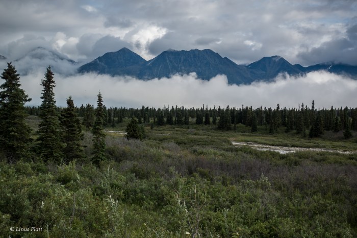
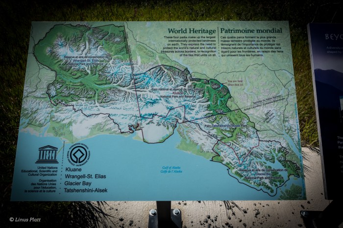
Some folk’s call the ride in question the ”Alaska Golden Triangle”, which is a misconception since most of the ride occurs in Canada’s Yukon Territory. The route however, starts in Alaska, crosses British Columbia, traverses about 180 miles of the Yukon’s mighty interior, crosses back into B.C., and finally ending in Alaska at Skaguay. The first few miles and the entirety of my first day pedaling consist of the Chilkat and Klehini River corridors through the beautiful Chilkat Valley, ending at the Canadian/ U.S. border and the beginning of the climb up to Haines Summit, more locally known as Chilkat Pass. This Pass separates the interior of Northern B.C. and the Yukon from the coastal and heavily glaciated Chilkat Mountains and Alaska’s ice capped Coast Range, of which temperate and maritime systems exist at their feet. It is in this coastal region that Haines, and my home exist.
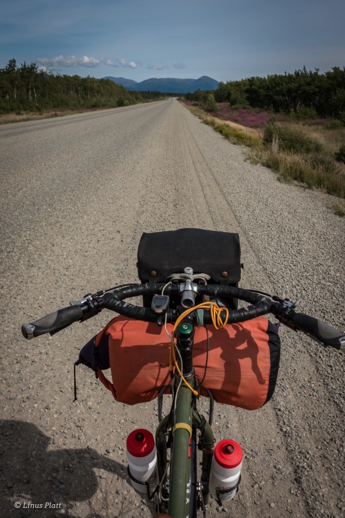
Going to bed a bit late and waking casually, I dress in my normal bicycle traveler garb consisting of loose fitting nylon pants, t-shirt, Loose fitting long-sleeve shirt, and lace up cross training footwear. Onto the Ogre, I spin into town to meet with Angela and grab some coffee and breakfast before commencing to the endless highway.
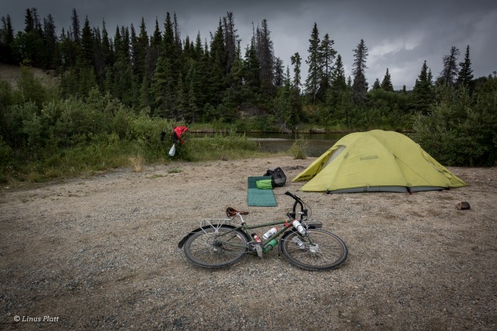
After a casual time at Sarah J’s eatery in Haines, I say goodbye to Angela and begin the flat and pleasant cruise up the highway in hopes of finding a good camp near the border. Hours later, a faint path appears on the river side of the road leading through the Alder thickets and ends abruptly on the Cotton Grass flats above the Klehini River. A great camp with views of the Saksaia Glacier and fine and tasty drinking water direct from the river has me smiling on this first evening of the trip.
Many bicycle travelers it seem have a burning desire, especially in the northern tier, to seek out camping in “official” and pay campgrounds where other people gather. To my thinking, this never really made any sense, not here in the northern wilderness, where some of the best and most plentiful free range camping are to be had for the taking. Why pay to sleep when one can create their own world wherever one wishes? Many claim it is their fear of Bears. After spending more nights out in the Alaskan and Yukon bush than I can count, I believe that the Bears have far more to fear from Humans than the contrary. Of course extreme occurrences can happen, but being smart about the way one camps greatly diminishes these chances. In fact, I believe that having Bear problems are increased in public camping areas where Bears may be conditioned to Humans and their glorious trash. As far as the social thing is concerned, well, to each there own. Camping alone in these wild places allows me breathing room and a purposeful reflection towards the natural world and creates in me a great and humbling respect for it. This is where I can watch the river flow and the Falcon soar; hear the wind blow and smell the sweetness of the North in the air unencumbered by a Human world that tends to feel dominance toward all I see before me. That said, loneliness could from time to time drop in for an unexpected visit. But not tonight.
The morning sees rain pattering the rain fly of the tent and I must say I dread it, since today is a big climb up to Chilkat Pass, where I am hoping to spend more than a day hiking and bagging a peak or two if the weather cooperates, But, cooperating it is not and I pack up my little world and spin the mile up the road to the Canadian Customs gate and soon I am climbing upward into the big grind known as “Marinka’s Hill”, the primary climb up to the pass. The rain shows no sign of letting up and I don rain gear and continue, sweating as much on the inside of the clothing as the rain on the opposite. As the storm intensifies, I realize there will be no hanging around and leisurely climbing mountains, but instead, waiting the fury out tent bound. Just past Three Guardsmen Lake, in a low hollow just before the main summit, I pitch my tent and dive in. For the next 18 hours I read, eat, drink a beer or two, and sleep. The following morning the rain is continuing, but I must go on and the tent is put away wet and the pedaling continues. At the pass proper, the rain stops, clouds open, and glorious sunshine reveals itself, if only for a few minutes. Then it begins again. But heavier this time. Soon torrential downfalls of drops appear, and for a moment, even the roadway ahead is barely visible to my eyes. Although a part of the journey, especially in the North, rain can make the difference between pure suffering and pure bliss on a bicycle voyage.
Later, after the rain lets up, I cross the Yukon’s Takhanne River and set up a pleasant camp next to the water and bathe my foul clothing and myself. Snacking on my supper that evening, I watch a Hawk harass the Swallows at the entrance to their mud nests burrowed deep into the ancient riverbank. Clouds gather and then part again while the sun peeks in to cast great and colorful splashes of yellow and orange against the rocky mountainsides before me. Patches of deep blue sky swirl around the sun/cloud union like a predator in pursuit. At midnight, a Loon cries out from somewhere nearby, and the only thing stirring now is the soft and occasional breeze gently touching the tops of the Spruce and Aspen stands situated nearby camp.
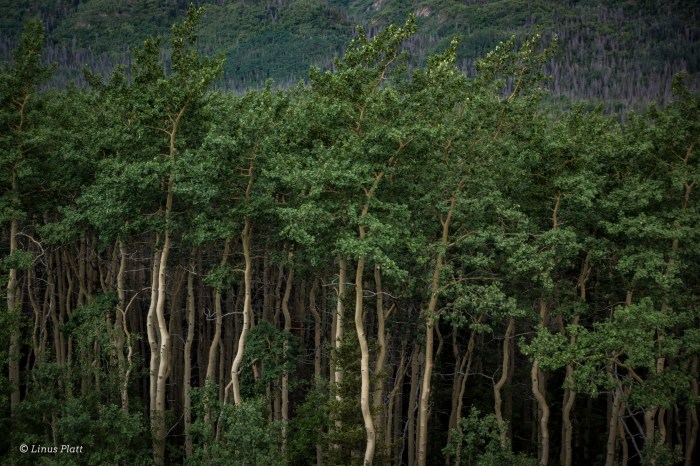
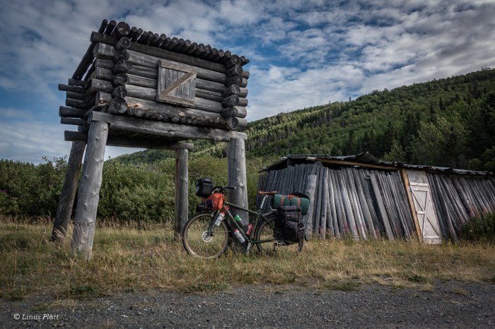
To my ears, the call of the Loon is one of the most enjoyable and haunting sounds coming from the forest and lakes. It is nearly as engaging as the sound of the Wolf howling in the dark of night. And as I pedaled the next morning up a monstrous Yukon hill, one of the biggest of the trip, the Loons were creating a symphony of joyous monotony pushing me upward and over that mound and deeper into the great Yukon interior I love so much. I meet a 64 year old French man on a decrepit bicycle, heavily loaded and carrying an axe for which to chop twigs for his home made hobo stove. He has spent a great deal of his life traveling by bicycle in various parts of the planet, and travel in these parts is not alien to him. Later in the day, I take a side trip to the ancient native village of Klukshu. A side trip of about a half mile leads to the small but Salmon heavy Klukshu River, where native people have been harvesting Chinook, Sockeye, and Coho Salmon for millennia. I arrive at the bank of the tiny river; a Sockeye splashes about as it sees me, there is not a soul around but the fish and myself, lest a Bear hidden in the forest nearby. The village is deserted. There is something going on here that is unexplainable; there is an ancient sensation that I am somehow connected to that feels both like sadness and deep connected love. The air feels thick with history and community. Tears swell my eyes as I sit next to the river; this strange place I have never been feels like home. It is strange indeed. If there is such a thing as past lives, then I’m certain I was a Native North American. I pedal onward and past the equally haunting and beautiful Kathleen Lake and the beginning of the colorful and rugged Kluane Range, forefront to the overwhelmingly enormous St Elias Range and Mt Logan. Home to the second tallest peak in North America and some of the biggest and expansive ice fields and glaciers on Earth. The Yukon is a mind-blowing place indeed. Soon I am rolling into Haines Junction for a meal and some re-supply on food and luxuries.
Now I am into the thick of things. The Alaska Highway is traffic heavy compared to the mellow Haines Highway, where trucks shipping supplies from Canada to Alaska whiz by at maximum speed and clueless tourons barely in control of bloated recreational homes-on-wheels as big as my house meander down the pavement, gawking at the scenery and not watching the road, too lazy or disinterested to actually stop and explore beyond their steering wheel, most of these southern travelers never really see much at all.
The pedaling is flat and windless; miles fly by. The Ogre slithers along in silence. The endless boreal forest of the interior swallows me up and I am one with it. Arctic Ground Squirrels scurry in and out of the roadway as if attempting to throw themselves under passing vehicles. I often hear bicycle travelers complain about the sometimes endless and monotonous stretches of Alaska and the Yukon’s boreal timberland, saying that it is a dread to ride through it. Beats riding through most anywhere down south if you ask me. I connect with this forest; to me, this boreal play land is an endless supply of tranquility, animals, lakes, rivers, muskeg, swamp, taiga, streams, and beauty. There is a living breathing force here that cannot be ignored. To me, there is nothing monotonous about it. Riding through endless highway traffic and Human civilization is monotonous, dangerous, and disturbing-nowhere to camp either.
The climate and terrain is changing rapidly from a wet mountain environment, to an almost desert like boreal landscape that reminds me somewhat of western Colorado. A several mile gravel section of road appears near the Native village of Champagne, and I unknowingly watch as the last stream goes past and some 25 miles later, I am running low on water. At the 61 mile mark for the day, I emerge on the banks of Stoney Creek; a crystal clear mountain stream perfect for both drinking and bathing, and with an endless supply of ripened Raspberries growing adjacent to it’s flanks. I call this lovely place home for the evening and settle in with a sizeable grin adoring my mug, all the while snacking on raspberries for dessert.
In Whitehorse, I’m tossed into a world I have not seen in a long time. Since moving to Haines nearly three years ago, I have not left at all, except to go see an orthopedic last year when I broke my ankle at work. Haines is a quiet little Alaskan town; very little commotion at all. Whitehorse on the other hand, although quite tame by modern city standards, was abrupt, fast, and in my face a bit. I actually like Whitehorse. It is a small city of about 40,000 souls, with tons of mountain bike and hiking trails, the glorious Yukon River, and surrounded by endless wilderness. But on this day, to me here and now, I just wanted to get through it and back to my forest. Pedaling through town finds me along the Yukon River and past the hydro power dam and on the shores of Schwatka Lake, a Human made reservoir with float planes and powerboats here and there, but still a beautiful and serene place to be camped. That night, I awake about 1:00 am and noticed the first star in the northern sky since late April. Summer is slowly closing down and the days are getting a hair shorter each cycle. Before you know it, there will be some of the white stuff back on the ground, the tourists will be back in Florida, Texas and all parts south, and the Bears will be heading to their high country denning grounds to await the next round of Salmon entering the rivers in May.
Heading south on the Klondike Highway in the morning, I pedal all the way to Spirit Lake and devour a breakfast there before spinning down into Carcross (Caribou Crossing) and the beginning of what is known as the “southern lakes region” of the Yukon. In this part of the Province, there are many, many extremely long, deep, cold water lakes; meltwater remnants of the massive glaciers that covered this part of the Yukon a millennia ago. These lakes are a thing of beauty to say the least. Encased in wilderness, and rising from them mighty mountain ranges so remote, few have seen their endless and omnipotent shores outside of a powerboat. Soon, I can see the coastal mountains rising from the horizon and the beginnings of small yet prominent glaciers adorning their sides. The road now traverses the Windy Arm of Tagish Lake and around the bulk of Tutshi Lake, where this highway begins to tilt upward a bit, and the Yukon/B.C. border comes and goes. More climbing in the distance I can see, for White Pass is ahead, separating Canada from Alaska and the end of my Journey at Skaguay.
Finding no outstanding place to camp, I reluctantly pedal mile after mile, passing mediocre spots hoping the Golden Camp Spot will appear. After 76 long and exhausting miles, the fabled glory camp does not appear, and I throw down my nylon ghetto onto a deserted gravel pit and enjoy myself regardless, happy to be off the bike once and for all for the day.
Up bright and early the following morning I am sore, and there are rapidly moving clouds and wind coming through, but I feel good. It is only about 20 miles to White Pass from here according to my calculations. The road turns gently and ever so slightly upward from here and the landscape changes once again from the sub-alpine boreal forest to the higher and more colorful alpine arena of tundra, swiftly moving streams, and low lying brush and stunted Pine and Spruce. The route follows a glorious emerald river, adorned with many rapids and small waterfalls. A Bald Eagle soars overhead, and a Gull meanders behind, perhaps hoping to reap any benefits the Baldy might conjure. The wind picks up and it is a struggle to keep the Ogre upright on the hills. At timberline, the first of many low lying alpine lakes appear, and the stiff breeze grows fierce. Glaciers show themselves briefly during interludes in the cloud cover and before long they disappear once again into the thick alpine mist. Near the pass, I clamber over granite boulders to get a good look at Summit Lake and onslaught of the storm; wind and whitecaps embellish the lakes surface. A Gull scares up and hovers over me, squawking loudly that I must leave. She must be protecting a nest. I wish her well and skedaddle back to the bike and finish the last bit of the climb to the pass. At the top, a great and magnificent alpine meadow sits below and decorated with a mighty waterfall, so picturesque it is difficult to believe it real. At the pass, the weather is foul, and thoughts of espresso and a hot meal entice me. I peer at the highway ahead and it is a steep downhill for 14 miles to the sea. I had ridden up this massive hill back in 2013 when I rode from Skaguay to Deadhorse to Valdez, so I had gained a healthy respect for it’s magnitude. After tossing on my jacket and sporting hat and gloves, I fly downward and into the fantastic canyon, past more waterfalls and jagged peaks and soon there is no more. A gigantic cruise ship appears a half mile off; perched in the waters of the upper Lynn Canal, it’s passengers flooding the streets of Alaska’s biggest tourist attraction. I meander through the insanely crowded streets attempting not to hit or be hit by those not paying attention, which are many. It is a shock to the senses again. Haines will feel quiet and pristine compared to this insane asylum. Later, after a meal and some casual town observation, I board the marine vessel Le Conte for an hour ride down the canal to Haines, where a six mile ride from the ferry terminal deposits me back at my quiet little crib.
All in all, I had ridden most of this trip previously: the Alaska Highway portion back in 2011 when riding from Moab to Fairbanks, and the Klondike Highway/White Pass section in 2013 on the way to the arctic. Only the Home stretch of the Haines Highway over Chilkat Pass were new, but it is an outstanding pedal through some of the most beautiful countryside the North has to offer. I may even ride it again. Complete with a side trip to Klukshu, some exploring of random dirt roads in the forest and the pedaling in Whitehorse and looking for camp spots, I had pedaled about 385 miles over eight days. I can’t think of any reason why one would attempt to do it any faster; there would be too much to be missed, and in my opinion, far less enjoyable. These trips are not a race folks; they are to be felt and appreciated.
The Ogre pulls off another one.


One of the key players from my “new” life in Alaska as a home owner has been largely absent these past two years. It is something that sparks my soul and makes precious life even more so. It is something to maintain a youthful and vibrant self and outlook. It is spontaneity. Seems these last many, many months, every move in my life needs to be planned, calculated, examined, and inspected, largely taking any playfulness out of it. Spontaneity is what makes trips and adventures youthful and fun.
Spontaneity is what I crave. Adventure is what I crave.
I wake up Monday morning, 4 days before my planned departure date for my two week bike ride into the Yukon. I am not feeling it; I want to go now. I dress for work as usual, but hope that my employer Dave and the rest of the crew will see fit to set me free upon myself so I may leave right away. Everyone at work gives me the thumbs up, wishes me well, and I drive home casually with a grin on my face to pack the bike, smoke some Salmon, shop for supplies, and relax a bit.
The next morning I awake and am totally ready: everything is in order, Angela is coming by at 8 for some coffee and I will hit the road. It is raining a bit, but hey, it’s Alaska in the summer, that’s what is does here! I’ll be out of range for the next couple of weeks; when I return, I’ll do a full write up and photo share here on JRB.
Stay tuned!!
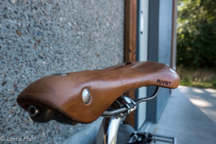
The bicycle know to me as the Surley Ogre has been on hiatus for some time now…over two years in fact. Like a horse put out to pasture, she has endured this lengthy time situated in the garage amongst the miter saw, planer, router, and other tools of construction. Not fitting in with these apparatus, she squeals and begs for a letting of road miles. In anticipation of an upcoming trip upon her to the mighty Yukon and beyond, I strip the old gal down to her bones and a cleansing and rebuilding ensues.
It has been far too long since the Ogre and I have embarked upon the open road together, and in a quick fit, I work out a stretch of time off from work and make preparations for us to engage the Alaska Golden Triangle; Riding from my house in Haines to Haines Junction to Whitehorse to Skagway. A 360 mile loop through the northern panhandle and into B.C. and the Yukon, ending back in the good ‘ol AK in Skagway, where a quick ferry ride home ends the adventure. With plans to leave on the 29th of July, and returning on the 13th of August, I must say that these bicycle trip are certainly not about the bike. Or even riding them. These excursions are about being there. Or more precisely, being out there and taking in the tundra, mountains, rivers, and wildlife. If I was in shape and looking to make some quick time, I would theoretically make the journey in six or seven days. I think not. I intend on going slowly and enjoying the vast and wonderful summer in the North. Summertime in the regions of Alaska, Northern B.C., and the Yukon are stuff of fantasy to me. It is a time of exploding life and glorious exploration. There is nothing better on Earth than summer in the North.
Having a couple of weeks lead time to the trip in question, I head out to test the newly constructed Ogre for a quick 20 mile excursion up the wonderful Haines Highway, and as luck would have it, a spectacular day of temps in the 70’s, glorious sunshine, and the glaciers of the Chilkat’s shining brightly.
The old girl, spaced out from many months at pasture, bucks wildly when I attempt to pedal forward. After a rough patch, we hit our stride and suddenly it’s just like old times.
As out of shape as I am, I am looking forward to that big nasty climb up Chilkat Pass and into the Yukon I love so much. Two weeks and counting…
Stay posted friends!


Let’s see now: I moved to Haines on November 3rd 2013 and it is now June 8th 2016. Now mind you, other than going to Juneau twice to see quack doctors about my broken ankle (I am not a fan of going to Juneau), and once heading up to Haines Junction in the Yukon with my Mom and Angela for a day trip, I have not really left Haines since that chilly day rolling down from Fairbanks in November more than 31 months back.
Seems my attitude has been at an all time low and a need for adventure has been halted due to my buying a house that I really cannot afford. Seems I have no time or money to enjoy the very reason I live here in Alaska. Things have been difficult for me at work as a result and finally, something had to give. Summer has finally arrived in Alaska, with temperatures in the 60’s and 70’s and daylight exceeding 22 hours now, I decide to break free for a weekend and head up to the Haines Summit area of British Columbia for a couple days of exploring and such. “The Pass” as it is locally known, is the dividing factor in separating the temperate maritime environment of the Chilkat Valley and Peninsula from the rugged alpine interior of B.C. and the Yukon. The Canadian border being 40 miles from Haines leads to the climb up Three Guardsmen Pass, and finally the higher Haines Summit being another 10 miles beyond. One Enters B.C., climbs the pass, then another 25 or 30 miles brings one to the mighty Yukon. The area around the pass is an area of high peaks, alpine tundra, glaciers, rivers, Ptarmigan, Marmot, Wolf, and Grizzly Bear. It is my kinda place to say the least.
After a quick visit with my buddy Gene on his sailboat in the Haines Harbor, I fire up the truck and head north. After a quick stop at Canadian Customs where I am grilled by the always grouchy Canadian Border Patrol, I am soon spinning the vehicle up the majestic landscape higher and higher to the land of rock and ice.
That evening I camp near the outlet of Kelsall Lake along side the mysterious Kelsall River. The mosquitos are thick, but the calls of the Loon and of the distant Coyote’s lull me to sleep. At 4am I pack up and continue north, into the Yukon just because I can. Being in the Yukon again is a fulfilling and sensational feeling once again. I really love the Yukon; there really is no place like it. It has a very distinct and isolated, yet remarkable feeling about it. It’s being up in the interior again that is putting wind in my sails…
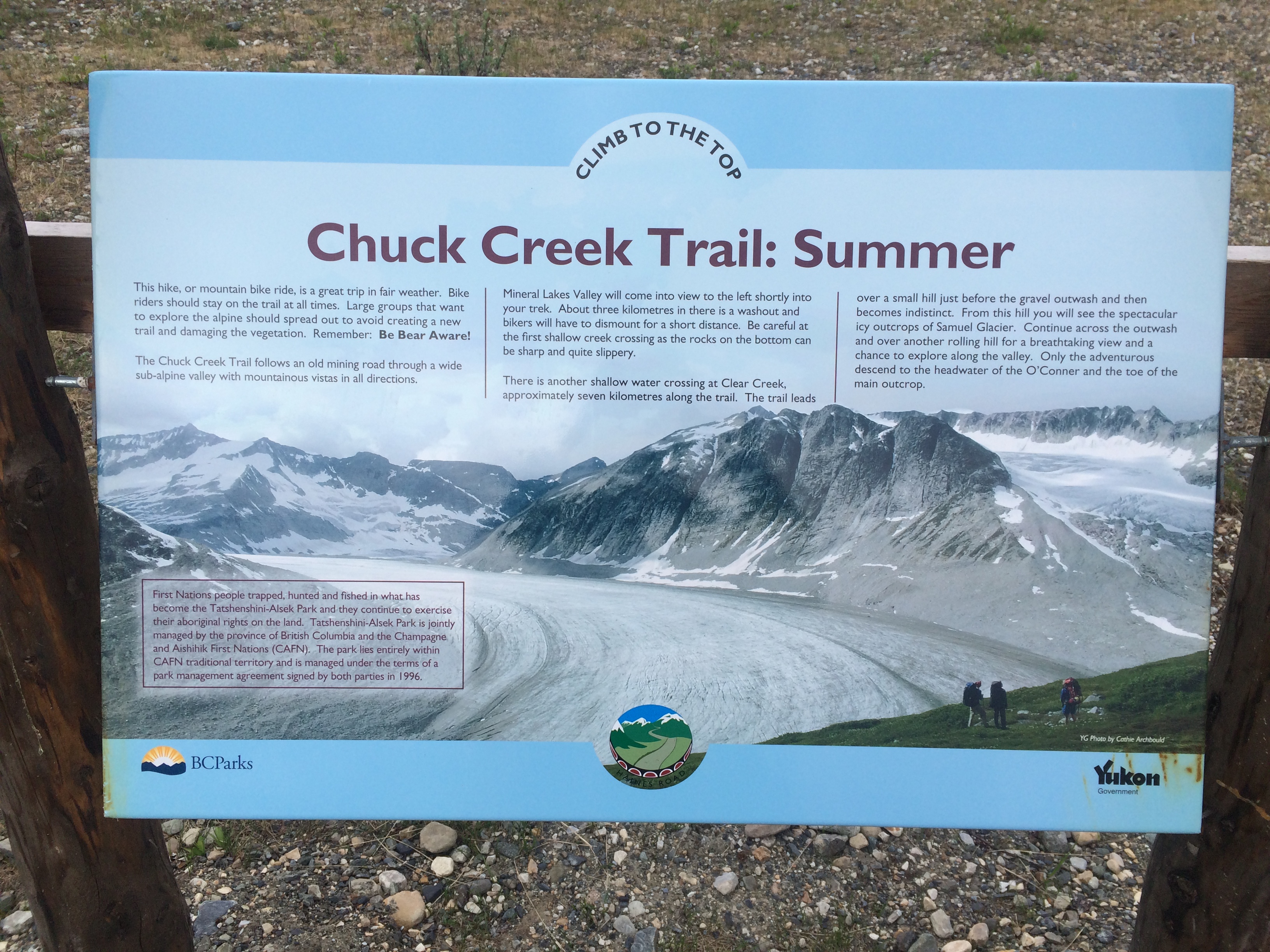
After a bit, I turn the truck around and head back south towards the trailhead for the Samuel Glacier, where and old mining road, after disappearing 4 or 5 kilometers in and turning into a true back country wilderness experience, leads to the wonderful Samuel Glacier, some 10 or 11 kilometers from the highway.
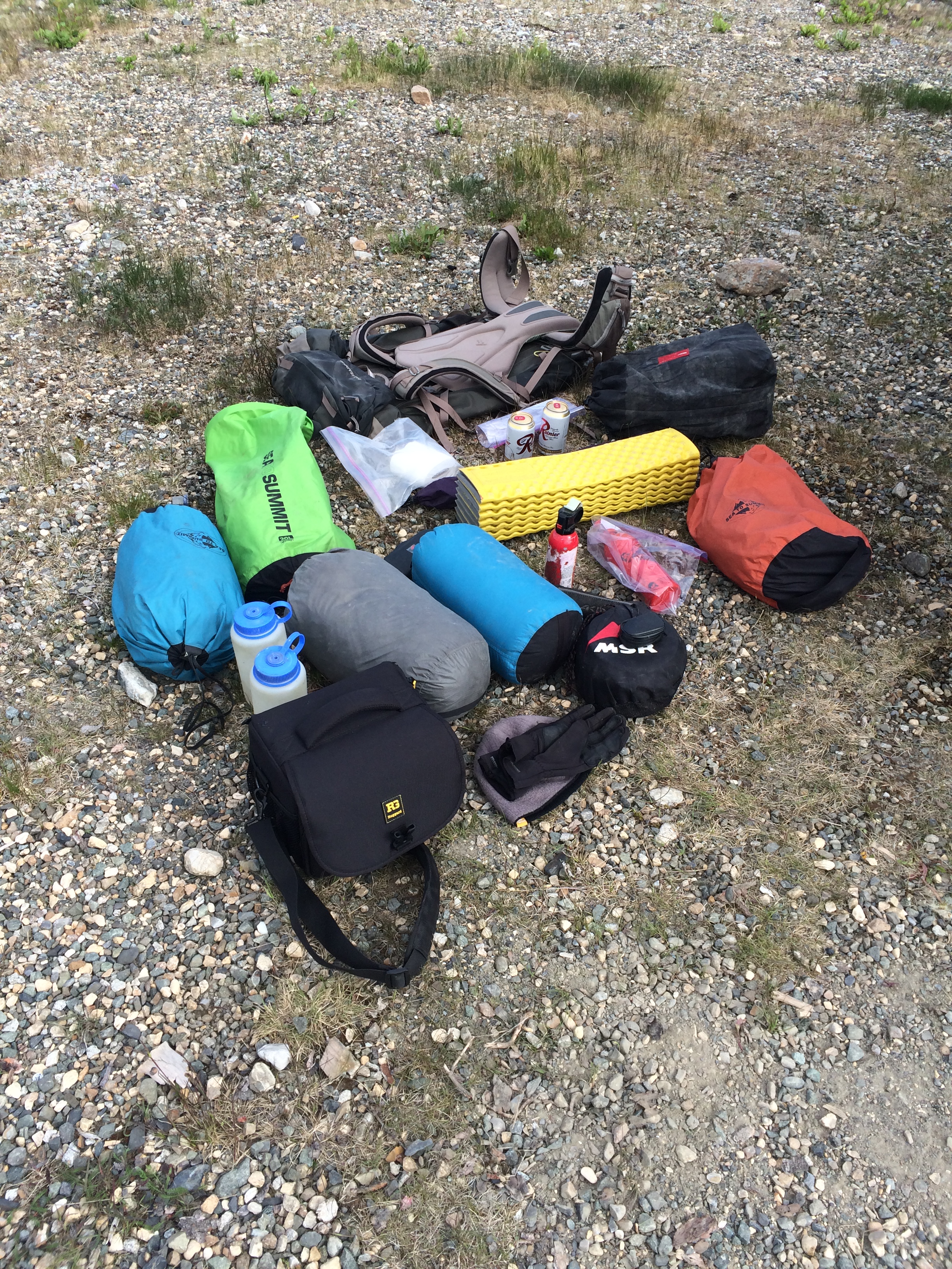
After finishing a breakfast of eggs and tortillas grilled over the trusty MSR, I pack up the backpack as light as I can to help make up for the fact that I will be carrying my Sony X70 video camera. I have currently my Canon DSLR listed on eBay, so decide not to bring it in fear of damaging it before a critical sale. The unfortunate reality of this particular photographic situation, is that my only photo option for this trip is the ever stupid iPhone! Man that camera sucks. But it’s what I’ve got for this adventure and after a brief packing session, I am on the trail.
The trail consists of an old mining road that is very easy to follow and is in exceptionally good condition. The trail wanders slightly uphill into a high alpine valley surrounded by streams, rivers and peaks. Groundhogs and Marmots seem to be everywhere; Ptarmigans scare up out of the low lying brushy tundra around every corner. The place is alive! I keep my eyes peeled for Grizzly Bears and Wolves, and soon I come to the first stream crossing that I must remove shoes for. The water is bitterly cold, but is refreshing to hot feet. After a couple more kilometers, the trail disappears under a vast snowfield hundreds of meters wide. I figure this is where my feet get wet permanently and dive in. Across the snowfield, the trail is no where in sight. I spy a river below and bushwhack to it’s shores, where another full blown crossing is in order. The trail re-appears briefly and I follow it till it once again dives beneath snow and tundra bogs. Gaining a high ridge, I spy a trail of in the distance, following the fast moving river I had just crossed. Had I gone the wrong way? It occurs to me at this point that I am here a bit too early in the year. July or August would be best I reckon. I trudge onward.
Soon, there is no sign of trail nor of human travel of any kind. It is just me and my running shoes, the snowfields and tundra tussocks, the mudbogs and river crossing, the Marmots and Ptarmigans. It is now genuine wilderness and I begin to feel at home. At every river crossing I come to, I simply charge right in, shoes and all and accept the fact that I now have wet feet. Traveling the valleys and ridges of pure trail-less tundra tussocks and mudbogs is fatiguing to say the least. I am nearing what I see is the end of my journey: The highland I am traveling suddenly stop up ahead another kilometer or so and what lies beyond can only be one thing: Glacier.
The tundra gives way to an alluvial plane of gravel and glacial deposits, with braid after braid of swift and dangerous stream crossings. At the edge of the plane, where it meets up with the endless tundra, lies a snowbank fitted with a long string of animal tracks. Getting closer, I see that the tracks in question are one of Wolf. A big one too. The tracks could be no more than an hour old as they appear fresh and crisp and un- molested by the exceedingly hot midday sun. I marvel at them and spin my head around in anticipation of seeing the animal, but I am alone. I cross the alluvial gravel bed and once agin climb onto the steepening tundra for a rather quick jaunt to it’s edge where the magnificent Samuel Glacier comes into view. I decide to drop down the other side of the tundra ridge and camp on a small hummocked shelf just a couple hundred meters above creaking ice. I am exhausted and once in the tent, I sleep a fitful sleep as the overhead sun is blazing hot in this barren and endless alpine tundra land.
A while later, I emerge from the tent, sun still high, and walk to nearby stream for water and photographs and some video shots. I see the Samuel Glacier and it adjoining glacial arm like tentacles from an icy giant protruding from the massive fault block pyramids of the Alsek Ranges that extend into the largest glacially active non-polar area of our planet, and home to the largest unspoiled wilderness on earth. I am fulfilled with great and massive appreciation for this place and I am happy to call it my home; Haines is a mere 80 miles away.
Back to the tent for supper and more sleep, I awake the following morning at 3:30 am to a gathering storm. I pack quickly and soon I am again bounding over tundra and listening to the rushes of the strangely human-like squawking of the Rock Ptarmigans. The first time I ever heard these creatures talking was in the Tombstone Mountains in the high Yukon back in 2013. The sounds they make are vaguely human and sound like a babbling insane person speaking nonsense. The first time I heard them was in the middle of the arctic “night”, and it disturbed me so much, I thought I was being stalked by a maniacal stranger hell bent on harming me. Then I peered from my nylon domicile and spotted the strange bird making these sounds, Since then, I have come to listen for their cries in anticipation.
Eventually, I come to where I have to make a choice and decide to follow the “trail” along the river back to the vast snowfield. I cross the river back and forth a dozen times or more and soon come to the snow and then the real trail beyond. I am back at the truck by 9 am and happily changing into dry socks and shoes.
A slow and pleasant drive south via the magnificent Haines Highway finds me back at home by mid morning, where a shower, hot cup of coffee, and a reflection of a successful weekend are in order.


The sensation evoked in this time lapse video I just finished putting together is an accurate depiction of how my heart feels about the North Country… Some of the shots are from the past, some have never been seen before. Shot entirely on Canon’s 60D with various lenses, and edited in Final Cut Pro 7 and After Effects CS6. Photographed in British Columbia, Alberta, The Yukon, and of course, Alaska. Enjoy…

When most folks think of British Columbia, they conjure up images of Vancouver, Whistler, the areas around Kamloops or Fernie. These are all fantastic places filled with the the awesomeness that B.C. has to offer for those seeking beautiful wilderness forest, bears, rivers, or to spend the ever fascinating “Loooney”, or “Tooney” (one and two dollar coins). There are other (many other not mentioned here) places in B.C. that strike a resonant note with me. Bella Coola comes to mind, of which I have friends established there.. You know who you are! Bella Coola is a place I wish to visit sometime sooner than later, but who knows how the cards may fall!
For me, the Cassiar Highway, heading north from Kitwanga and highway 16, is without a doubt, the creme de la creme of northern British Columbia.
The Cassiar, which is an alternate route heading north/south, of the more largely known Alaska Highway,and is a is a fine example of Northern British columbia’s offerings of beauty, soitiude, and grandiose scenery and wildlife.
Highway 16 which intersects the Yellowhead Highway, is also know by some as the Highway of Tears. Between 1969 and 2006, some 18 cases of missing persons or homicides of young girls have been reported. Riding through this section enroute to highway 37, The Cassiar, felt surreal to me, knowing there has been a great mystery here. My heart goes out to all of the families who are in pain from these incidences.
The last major town departing from the Yellowhead is Smithers, British Columbia. Smithers is a a fine town, with a strong bicycling community, including a DH and freeride scene upon the local mountains and ski hills. I spent an entire afternoon here, seeking out bike shops who might have the required length of spoke that I required. It was also a great place to get re-supplied for the long length of road ahead of me known as the Cassiar Highway. Just north of the town, lie splendid mountains, sporting moderate looking alpine mountaineering routes that might leave a Sierra climber in awe. A place called Glacier Gulch features two extarodinary peaks with a small glacier at their base. Ice couloirs bearing the gifts of alpine ice lie above, beckoning me.
Heading north from Smithers, I passed through the ancient Native fishing village of Moricetown, situated snugly against the mighty Salmon festooned river of Bulkley. And on to the hamlet of New Hazelton, which, though a place of unfounded beauty, did not stop raining once. I settled into a cafe there, and ate a magnificent breakfast, re supplied on beer, and headed for the Cassiar of my dreams.
I cross the mighty Skeena River, and upon entering the Cassiar, my mind began to fill with a wonder I had really never known. Of all the adventures taken past, climbing, mountaineering, bicycling, wandering, I had never felt such a presence before. It was an age old feeling of family and gathering and fishing that caught my imagination as though I had been here before. I felt strangely at home, yet I also felt an unnerving sensation of detachment that I was not expecting.
All day in the rain, pedaling, thinking, feeling these great emotions of past, I began to become as weary as I had ever been, but pedaled on, in hopes of engaging the Cassiar as fully as she deserved, I finally needed to stop. The area was festooned with brush so thick, one cannot really camp with any amount of enthusiasm. I spy a free gov’t campground, but, due to the constant rain, is totally flood out. I try to ride my feeble bicycle into it’s innards, but am rejected like a vomitous expulsion, that forces my weary body back to the road and onward in search of salvation.
After a couple more miles, desperate, a gravel pit area appears like a welcome wagon from hell, and I pull in. My first sight? A dead Grizzly, shot, I presume. The image brings an anxiety and fear of the Bears of which I had not come to terms with yet on this journey. Too exhausted to care, I pull a little further in and call it a day. Cottonwoods bigger than I had ever seen before sprouted the forest around me; I eat a meager supper, hang my food bag in said trees, and crack open a beer and a belt of Rum, and the world washes away, fears dissipate, and I begin to feel like I have finally come home.. The bear spray was not even clutched that night, as it had been so many nights before. The glorious adventure was now in front of me…
The next 24 hours become a mind numbing, but peaceful, pedal, through the boreal forests of the region, that, with the weather now clear, sunny, and glorious, finds my mind at peace once again.
These forests lead on and on toward an area, what one native in Smithers told me, “The Grizzly Bears there will make a small snack out of you”. The area in question is Meziadin Junction, where the highway splits to go either west, to Stewart, Alaska, or north, further up the Cassiar. This place, according to the locals, has the greatest concentration of Grizzlies in the central B.C. sub coastal area. I never saw a one, sadly.
I pedaled for 6 more days through this Alice in Wonderland of wilderness, passing through some of the most heart felt forest and landscapes my heart and mind could conjure up.
Passing through Dease Lake, I find that there is a small town there, and sporting a decent grocery store, laundrymat, liquor store, and cafe. This felt like a miniature vacation of sorts and, camped on the beaches of the local swimming hole and fishing spot, I drink and hang with the local native folks and learn of the long winters and of fishing and the hunting ways of native peoples. This makes me smile and I move on..
North of Dease Lake, I can feel the the landscape begin to change towards a more northerly and remote arena. I can smell the Yukon from here.
The last night on the Cassiar, I find a serene place next to a fine river and begin to unpack the bike. Seconds later, a van loaded full of Native teens pull in and open the doors; all pour out and declare their victory that day. They unfold a tarp in the back, revealing a large male Ram, shot on a nearby ridge, and declare that Ram meat is a delicacy that cannot be beat. They say that they intend to gut the creature here, next to the river. I know that the ensuing gut pile will attract bears for miles and I split. Later, I find a decent camp further up, next to the same river, but the skeeter’s are the worst I have ever seen. Welcome to the north!
The next day, I pass through the surrealistic remains of a forest fire, that given the eerie feeling of the last 48 hours, fit’s the bill. Later that day, I reach the Yukon border and the junction with the Alaska Highway, and already, begin to miss the Cassiar.
All told, the Cassiar highway is a place like no other I have ever been, and hope one day, to experience it’s haunting delicacies once again. I urge any one who might embark on a pedaling journey to Alaska, consider this as a superior alternative to the lower Alaska Highway through northern B.C.
And that’s all I have to say about that…
“How Can I Be Lost, When I have no Where to Go..?”
-Metallica


The following is an excerpt from 2011.
While not really a new post, per say, it is a recollection of the past in order to glimpse the future, and a chance to do some creative writing in order to get psyched for Alaska in May 2013!
The storm finally passed over this part of Idaho, and my knee swelling subsided, so it is time to hit the highway again. After crossing the Snake river, I entered the Snake River plains and north into Idaho’s fantastic mountains. Spent the Night on the Salmon River near Challis and really started to enjoy myself. For the next 2 days I pedaled and photographed my way up the Salmon River corridor, stopping at a fantastic hot spring that David Schipper told me about. This place was a one of a kind… a 3 mile hike up a beautiful and steep mountain canyon bring one to a literal waterfall of hot water, with pools of various temps below. Totally natural and with unforgettable views.
Onward…. up the Salmon to it’s head waters and over Lost Trail pass and into Montana. More rainy pedaling and a stop in Missoula to buy a new H2O filter put me on the map of the north country. I stayed in Whitefish for a couple of days to relax, and then bolted for the border.

British Columbia! B.C. is beautiful! I pedaled north, following the Kootenay River most of the time, and eventually entering Kootenay Nat’l Park at Radium Hot Springs. After climbing up the 10 percent pass into the Rockies proper, I stopped at a small lake at it’s summit called “Olive Lake” and cleaned up a bit. It started to rain. Starting down the other side, I spy a small Black Bear cub, dead, on the road. I stopped, and shooed the Crows off of it, and pulled it out of the road and off to the side. It was no bigger than a large dog. It’s fur was incredibly soft and claws very long. I spoke to it for a bit and bid it farewell to the afterworld and continued on. A quarter mile further, I look down and lock eyes with a Grizzly! I stop and speak softly to it and take some photos. Eventually, it wanders into the forest. Awesome! Then, not 200 yards further, I see a Black bear that was WAY big! She spots me and instantly bolts… Talking to a park employee later, I am told that the Black’s name is “Olive” named after the lake nearby where she is known to habitate. Apparently, she births 2 cubs every 2 years. The cub I found was hers… very sad
The next day, still raining, I finally cross Vermillion Pass and the continental Divide, and reminice of when my climbing partner at the time, Ron Alexander, RIP, pulled in here on our first trip of several, and climbed the N. Face of Mt Stanley. This place, these mountains, are the stuff of my dreams. Ron and I, and other partners went on to do the N. Faces of Robson, Athabasca, The W. Shoulder Direct on Mt Andromeda, and quite a few others. It has been nearly 20 years since I was last here. I’m feeling pretty blown away…. I am now at Lake Louise for the third day and now the rain has turned to snow. according to the weather forecast, it should improve tomorrow… then I can get to the Columbia Icefield where the REAL action is!
Well, my last update was in Lake Louise, Alberta, and now I am in Whitehorse, Yukon Territories. It has been one helluva ride, lemme tell ya…
I finally escaped Lake Louise and in the rain headed for Bow Pass and the Icefields. Snow “flakes” the size of golf balls greeted me on the descent towards the Sunwapta River. Once over Sunwapta Pass, I was greeted with the familiar views of the Columbia Icefield, Mt Athabasca, Mt Andromeda, Slipstream, and the Grand Central Couloir on Mt Kitchener. When I spied the Grand Central, I could see it still, after all these years, giving me the finger, from a botched attempt at climbing it over two decades ago…
Cruise up to Jasper and re-supply and on to the B.C. interior, stopping at the magnificent Crown Jewel of Mt Robson to shoot a time-lapse or two.. Robson rises over 10,000 feet from its base, and pretty much controls the weather patterns over the Northern Rockies.

Down through the beautiful Robson Valley, I am immersed into a world of forest… Birch, Alder, Poplar, Fir, and Spruce. There is even temperate rain forest here with Hemlock and Cedar. The rivers are big, glorious, and plentiful.
I enter Prince George and am thrown into the grips if everything I hate about cities, but soon I am out and on the Central B.C. Plateau. Mostly logging and farmland, it is not my favorite place on the trip, as there is very little camping and “open country”.
I rest a day in Burns Lake and head for Smithers, B.C.
Smithers is a great little mountain town that blows doors on ANY Colorado or California mountain town. I would live here if I could… A couple of days later and I am on the fabled Cassiar Highway, one of two routes to the Yukon and Alaska. It is the more westerly, and remote of the two. The other option is the lower Alaska Highway. With only one re-supply near the end, I load up with 9 days of food and commit myself.
The first night, I pulled into an open area near the road and spot a dead grizzly, shot I presume. I am too tired and wet from a full day of rain to look elsewhere to camp, so I camp. I become intensely paranoid of the bears and sleep with one eye open.
Over the next 8 days, I witness some of the most remote and incredible scenery and wildlife one can see from a paved road. Big, glaciated, peaks, bears, moose, eagles, rivers, lakes. It bring tears to my eyes the natural balance I see before me, and makes think hard on where the human race is headed and why. There is much craziness in the world, but not here. Everything is as it should be.

Eventually, I come to the Alaska Highway, and pouring rain for many days. Riding a bicycle this far, this many miles, this many hours, in this much rain does funny things to ones mind. It MAKES you take a really hard look at yourself and the world around you. It is tough. I’m enlightened as I pass through Tesli, Yukon, and talk with some of the first nation people. They tell me of life in the North Country – of hunting and fishing, and of living through the long winters.
Finally I roll into Whitehorse! The sky is blue over the mighty Yukon River.. it is the first nice day in a week and I am glad to be ALIVE! Well, I am now in and have been for a while, hangin’ in the AK… I love it here. I think my last update was in Whitehorse, so a lot has happened since…
After gearing up, so to speak, in Whitehorse, I pedaled up one of Alaska Highway’s worst sections.. frost heave has tore up the road surface so bad that it is not even a close relative of pavement anymore; furthermore, RV’s SUV’s, and Semi’s all seem to want to SPEED UP, rather than slow down, spraying me with gravel. Luckily this only lasts for 10 or 15 miles, and the magic road re appears.
About a day out of Whitehorse is where things began to change dramatically for me, in terms of country side, and therefore, pedaling bliss. This is where I begin to see signs of granite and big mountains appear, bearing the gift of glaciers.
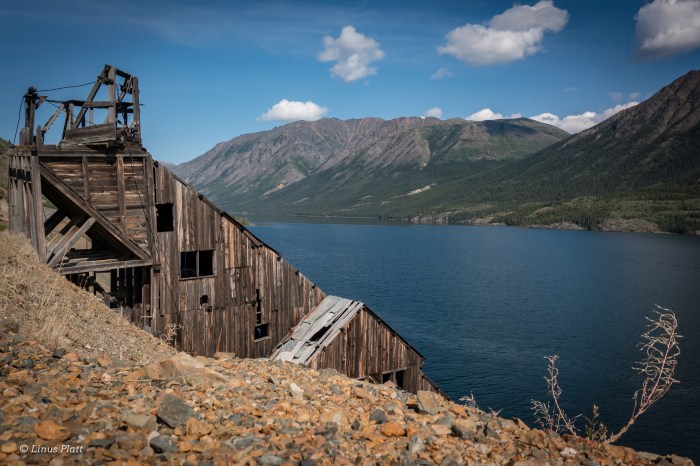
I arrive in Haines Junction, what a nice little town with a fabulous bakery to boot. Up against Haines Junction, is the Kluane Range, a “front range”, or interior range of the Mighty St. Elias, the second largest chain of mountains on the continent and sporting the western hemispheres largest glaciers. It is remote and magnificent. For the next several days, I pedal along side the St Elias, and it’s largest glacial fed lake, Kluane Lake. This place is very remote feeling, and it’s people are mostly of 1st nation Natives, of whom’s company I came to immensely enjoy.

After leaving the Kluane area, the Alaska Border became an obsession, as this part of the Yukon began feeling stagnant, and some of the worst people I met
on the trip seemed to inhabit this area.. I am not talking about Native People’s, mind you… Finally arriving in Alaska, It begins to rain a rain that only Alaska is famous for, and for the next 8 days it did so. I spent a couple of days in Tok, relaxing and checking things out. I stocked up on food, since I was now in “cheap” Alaska, compared to northern B.C. and the Yukon. In fact, financially, Canada just about bled me dry…
Up to Delta Junction and down the Richardson Highway, I ride and push my bike into the backcountry to an area known as Rainbow Ridge; 8 miles back and I find myself standing above the awesome, Cantwell Glacier. I stay here for 3 days, and manage to get back even further, to yet another glacier and bag a 3rd class granite “spire”. I am enthralled at the beauty and descend in a storm that chases me back to my tent and a victory cocktail!

The journey continues, and I am now at the meat and potatoes of this trip: The Denali Highway. The Denali Highway is 135 miles long and 110 of that are gravel and traverses the entire central Alaska Range, covering some of the most spectacular scenery Alaska has to offer. I take 4 and a half days to cover this ground, and spend an entire day and a half camped atop a ridge overlooking the Susitna River Headwaters, the Susitna Glacier, the West Fork Glacier, Mt Hess, and finally, the AWESOME Mt Deborah. Mt Deborah is a peak that I want to climb incredibly bad. It is a haunting sight to my eyes. It is a peak that David Roberts also obsessed over, both in climbing it and writing about in the sixties.
I am camped on this ridge primarily for one reason; to capture a striking Timelapse sequence of the mountain in question. Unfortunately, as is usual in the Alaska Range, the view is obscured by clouds. I shoot what photos I can and by 11:30 pm I am asleep. The rain stops, and at 1:30 am, the clouds begin to part and the weary Alaskan Sun begins to “set”. As this sequence unfolds, Mt Deborah and Mt Hess appear, Alaskan giants, Himalayan in size, and engulfed in a red, sunset hue, Alaskan Style. I cry hard…

This is what I came here for. The feeling of seeing these unbelievable peaks is overwhelming to me and I cannot fully express what it is exactly what they mean to me.
I finally get to the end of The Denali highway, and , I am in luck because Denali herself appears! The roof of North America, and one of the largest peaks
on Earth, I only see her summit poking from the clouds. That would be the only time I would see Denali on this trip…
The next few days are a blur to me, of rain and monotony as approach the populated southern coast of Alaska and leave behind the Alaska Range that means so very much to me… So, I guess for the time being, I now reside in Eagle River AK. It is about 12 miles north of Anchorage. I have a small job here, working on decrepit bicycles and splitting firewood for the campground guests.. at 9 bucks an hour , I’m not going to get out of Alaska and down the west coast as planned; perhaps something will arise unexpectedly…

I went for a long walk by the river and through the forest yesterday, looking for inspiration and beauty. I was looking down, examining some strange markings on the ground, when I looked up, a mighty cow Moose was standing no more than 10 feet away, slurpping up forest foliage. I had heard of her, yesterday, from some campers, and here she is… one leg, her front right is badly injured. Broken from the looks of it. The strange ground markings I had spotted, were, in fact, the hook of said leg, dragging on the forest floor. I spoke to her softly for a bit and wished her healing energy. Then I said goodbye… If her leg does not heal, she will not make it through the rapidly approaching winter; she will be wolf food. When I returned to my camp, the front mosquito netting on my tent door was gashed open from a familliar black bear and her cubs I had soon so many times in the last few days. Today my goal is to repair this as the skeeters are pouring in…

Well, all said and done, this adventure was extraordinary, beautiful, difficult, and not really long enough, but the reality for me at this point is that I am out of financial means, and my family is beckoning my help as a carpenter to get some much needed work completed. My sister and her fiance bought a house and it needs much work… My Grandmother passed away last fall and her house is badly in need of repair in order to sell, and last but not least, my Mom’s house is in need of some attention as well… once these jobs are completed, I can begin figuring out how to make money for my next trip into the Great North Country…
My last update was some time back… I guess that my writing ability has vanished along with my trip. I now sit at the computer, away from the wilds I have kept so close to my heart, and now must “force” the creative juices flowing, onward, to my keyboard. I sat in Whittier, Alaska, for 5 straight days, in the rain, waiting; waiting for the ferry ( the AMHS “Kenicott”) to take me down to the “panhandle” of Alaska, and onward to the Inside Passage of British Columbia, and to land at my destination at Bellingham, WA. I spent a good portion of that time either sitting in the bar or sitting in my tent, interspersed with hiking in the rain and taking photographs when it was dry enough. At one point, the damn rain stopped for an hour, just long enough to take a quick hike up to Portage Pass and check out the mind boggling scenery there… views looking down on the fabulous Portage Glacier, views out onto the Passage Canal, and alpine tundra galore, all combined with some of the best light of the trip, made for some stunning photos.
Finally boarded the Kenicott and off we go for the next 5 days to Yakatat, Juneau, Ketchikan, and the surrealistic west coast of B.C. During this time I saw Humpback Whales, Orcas, Porpoises, Salmon, and more seabirds than I’d ever seen before in my life… it was an unforgettable trip.

After arriving in Bellingham, I was thrown into a world that was very foreign to me… People, traffic, stop lights, dangerous roads, country roads that seemed to lead nowhere, and a grim camping situation that would last the rest of the trip. Mind you now that I consistently “wild camped”(a term that a lot of bicycle tourists seem to us; I however, do not, because to me, camping is camping, and to me, camping means FREE camping). This “wild camping” thing was challenging down here in the states with all of the aforementioned things in the way… but , having the mind of an outlaw, I managed. For two and a half weeks I pedaled down and around Washington’s Hood Canal, the coasts of Oregon and California, enjoying the scenery and smelling the ocean air, but all the while, in the back of my mind, I was the longing to return to the North Country.
PROLOGUE:
About 3 days ride from Sacramento, up in the steep mountains of Northern California’s coast range, I came across a section of road so bad, I figured it would be suicide to attempt it on a bicycle. I am talking about Hwy 36 that connects Eureka on the coast to Red Bluff in the northern central valley. I spent two half days negotiating this spectacular road, and on the 2nd morning I got up and had every intention of finishing my ride, when I thought I might die when a log truck nearly creamed me. This road has 4 MAJOR summits, 12% grades. NO shoulder, with Redwoods growing right to the pavements edge, about a lane wide and HEAVY log truck traffic. I decided to put my thumb out and after a couple of short lifts, I ran into a couple from Roseville CA (basically, Sacramento) who offered me a ride ALL THE WAY to Sac… I took it.

Now I am living in the city, up to my old tricks as a carpenter and trying to get involved in my other passion of film making and post production activities. This new concept is very alien to me, yet it is good to be around my family once again. I have not forgotten the North Country, in fact am downright foaming at the mouth at the thought of returning there in the spring…
I am reading a book entitled: “THE LAST FRONTIERSMAN”, which is about a man named Heimo and his family that live year ’round in the remote N.E. corner of the Alaskan Arctic… it is enough to keep me from forgetting.
“The more I see as I sit here among the rocks, the more I wonder about what I am not seeing.” ― Richard Proenneke
The untold tales of paths trodden, fears conquered and battles won.
tracking inner and outer landscapes along the road to creating community
Adventures starting in the heart of Alaska
...A Life Simplified Is A Life Fully Lived
More than just a Summer in Alaska
Indulge- Travel, Adventure, & New Experiences
News and opinions on the environment in the Haines area and greater North.
Exploring and Photographing the Alaska Range
The Adventures of a Man, His Heart, and His Bike
Mapping the bicycle travel revolution.
Just another WordPress.com site
A fine WordPress.com site
Just another WordPress.com site
Since 1999
Iowa City ~ (319) 338-8900

You must be logged in to post a comment.