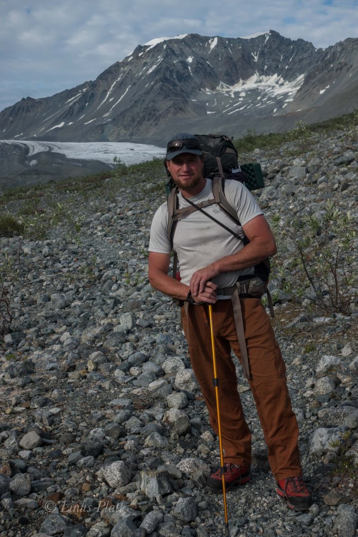
After leaving Haines and driving my thirty year old decrepit Toyota pickup across the Yukon to the Northwest Territories border, followed by penetrating the Alaskan Interior and riding my bicycle into the Wrangell Mountains by way of the splendid Nabesna Road, it was time to get down to some mountaineering. My old buddy Dennis from California was to meet me in Fairbanks on July 7th and after a day or two of re-grouping, planning, and getting the truck in order, we were off, heading south on the beautiful Richardson Highway bound for the Delta Mountains in the Eastern Alaska Range. The Delta’s are the most accessible and driest peaks in the Alaska Range and sit at it’s far eastern end in the rain shadow of the taller and more remote giants across the highway in the Hayes Range. Most of the peaks here are in the 8000 -10,000 foot range, moderate to heavily glaciated, and approaches are generally made from the Richardson Highway; however the eastern most peaks such as Mt Kimbal are approached via the Alaska Highway north of Tok and these approaches could be considered extreme, as in 40 miles up braided glacial rivers full of Alder thickets and Grizzly Bears. Our aim was to hike into an exceptionally easy area to access know as the Gulkana Group that is situated a few flat miles from the highway. In fact, from the Richardson, a 2 wheel drive dirt road leads to within a mile of the toe of the Gulkana Glacier.
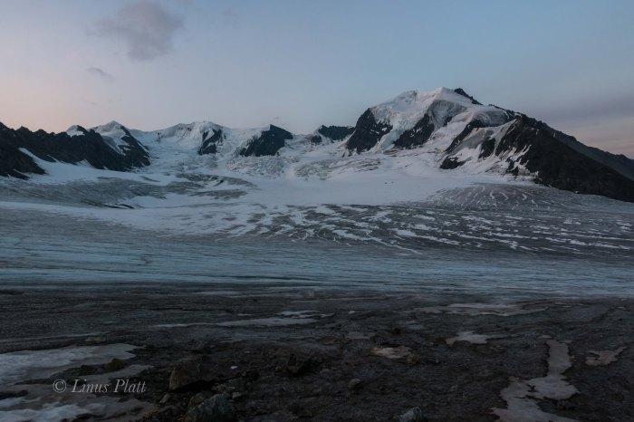
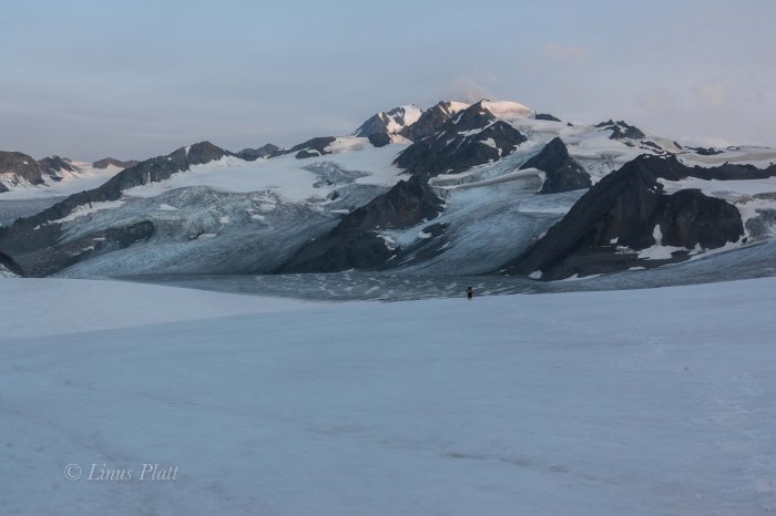
Driving south from Fairbanks, we spot the central Alaska Range rising gloriously behind the Delta River and since this is Dennis’ first trip to Alaska, we pull of to gawk at these Himalayan sized (bulk, not height) peaks far to the south. Passing through Delta, we stop for gas and a cup of coffee before continuing south and into the spectacular scenery the next 70 miles has to offer; to me, it is one of the best places in all road accessible Alaska. It is an area just north of the Alaska Range, where tundra, Spruce and Aspen forest, creeks, rivers, and rising glacial peaks dominate the landscape. The incredible numbers of Moose and Caribou here is staggering. It is a blue bird sky today and as we approach Castner Creek near the toe of the Castner Glacier, the White Princess, a striking triangular ice clad peak pierces the deep blue and we stop for a gander through the binoculars, as it is one of our goals over the coming weeks. But today, we continue on to the Gulkana and our goal of climbing Icefall Peak, which at 7,772 feet would be considered minor at lesser latitudes, but at 62 degrees north latitude, it is of the heavily glaciated variety and carries beneath it a magnificent, if troubling set of broken and daunting seracs known as the Moore Icefall. The slightly lower peak to it’s south, an un-named peak called Peak 7,680’ on the map, is by far the most striking peak in the cirque, with a long and jagged hanging glacial tongue descending from it’s upper flanks down to it’s base in the bowels of the Moore Icefall, and beckons to be climbed. I had seen photos of it and not found any information on routes or description on either peak; such is mountaineering in Alaska, where many peaks are un-named, rarely climbed, and undocumented. It certainly adds to the remoteness and sense of adventure that being in these majestic mountains affords.
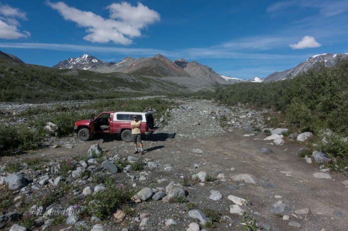
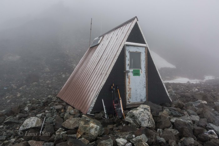
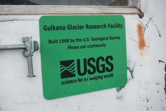
The old Toyota rattles up the dirt road perhaps 3 or 4 miles before petering out within a few hundred yards of a suspension foot bridge crossing Phelan Creek, allowing scientists, students, geologists, and climbers access across the small but raging glacial river and into the wide gravel valley beyond which accesses the tongue of the Gulkana Glacier itself. Due to it’s proximity to the road, the Gulkana Glacier area is a place of much study from the University Of Alaska and it’s GeoPhysical Institution, the USGS, and scores of other scientists and geologists. The USGS even built a hut at the 5000’ level high in the cirque back in 1968, which has served as a haven for climbers and skiers ever since.
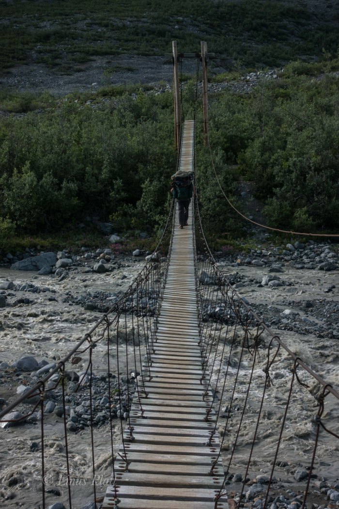
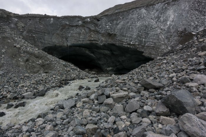
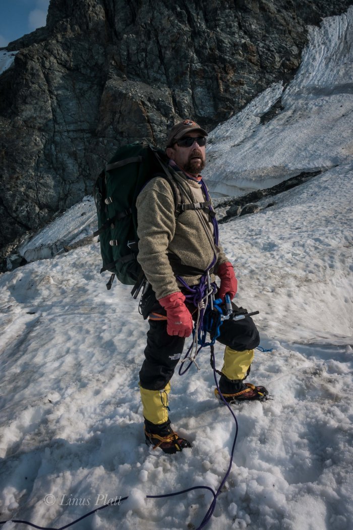
After spending a couple of hours getting our gear in order, we hit the trail and soon are delicately walking across the swaying suspension bridge just up river. On the other side, the trail climbs a short hill, then descends to the gravel basin beyond, where the trail meanders up valley for 1 or 2 miles, passing along the way a geologic gauging station, to the ice cave endowed snout of the Gulkana. We manage to get to the ice cave where we must make a choice: either cross the dreaded fury river in front of us, or climb up and over the massive cave via the endless talus and scree slopes above and traverse around it. Either way, we decide to make the decision in the morning and to make a bivi, but the last good flat spots are a half mile back, so reluctantly we head back down valley a bit to throw down our evening ghetto. That night, during the endless daylight, I hear crashing rock and icefall every so often, reminding me we are now in the real mountains and caution must be afforded. Coming to the ice cave once again in the morning, we decide that the safest way is to bypass the river by going up and over the cave from where the river flows. This circumnavigation leads to not only the toe of the Gulkana, but to another ice cave; this one is not blocking our way, but begs for exploration. I ask Dennis to join me, but he declines, so in I go alone. The ceiling is a deep blue color and scalloped smooth. It goes back a few hundred feet where I can see light… it is a beautiful example of a glacial ice cave and seems to connect with the cave that blocked us previously and the great and fearsome river can be heard erupting from it’s guts. After emerging from the cave, we are once again moving and soon on the tongue proper where a great moulin flows violently. We fill our water bottles and head upward on the debris covered glacier. Once the debris thins out, we are surprised to find that the bare ice is textured nicely with dirt and sand and that travel with out crampons is not only acceptable, but desirable.
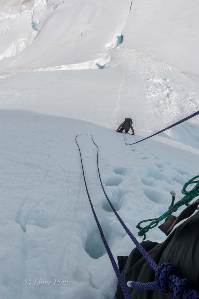
A clouded mist forms above and just as the vast and colorful seracs of the Gabriel Icefall show themselves, the mist descends upon us to create a condition of somewhat eerie circumstance; the glacier is silent, the rocky moraines hidden, and visibility becomes low. We truck onward and soon crevasses begin to appear; all are easily zig zagged around, and as the firn line gets nearer, we begin to see the remains of snow bridges from winter, and soon the depths of the menacing cracks are skimmed over with dirty and forbidding snow.Luckily these obstacles are easily avoided, and once reaching the top of a steeper section of the glacier, the upper cirque opens up, yet visibility remains low. We continue to meander and zigzag around the maze of crevasses and looking up suddenly, I spot the USGS hut. The tiny A-frame structure sits atop a large moraine, perhaps 400 feet above the ice, and after another hour of crossing through the crevasse fields and climbing the talus we reach the hut and enter. The steep walls of the hut are a notebook for every climber and skier that has entered this cirque for the last 49 years. Every available space has been written upon. Tales of climbing, humor, and general chaotic nonsense fills these walls. It is entertaining to read these as we prepare our dinner. There is a plethora of food in the hut and decide to take advantage of a bag of military cuisine consisting of Mexican Chicken whatever… these single military pouches contain every aspect of a meal, from main course, to crackers, to dessert, and to coffee at the end, which we saved for morning. After supper, I step outside to see the weather worsening; it is beginning to rain. Let’s face it, in the Alpine Zone on a glacier, nothing feels nastier than rain. And so it is… raining.
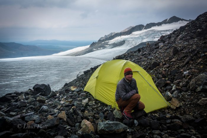
Dennis, as I found out on a climb on Silverado Peak in the North Cascades a few years ago, snores terribly. For this reason, I cannot sleep within 150 feet of him. Not a chance… That sound goes right through earplugs. Dennis seems to like the confines of the hut, so I go out onto the moraine and pitch the tent. I crawl in just as the storm intensifies and most of that night was spent trying to keep the tent poles from snapping; Guying the tent out properly was something I got lazy with and was now paying the price. After a few hours bracing from the inside, I put on my parka and go outside to fix the problem by attaching more guy lines and stretching out to larger rocks nearby. That did the trick and soon I was able to drift into sleep. In the morning, the wind had died, but the storm was far from over, essentially eliminating possibility of climbing anything that day or advancing our camp any higher. After breakfast, Dennis and I go out to guy out my tenet even better. Then back to the dryness of the hut for reading some of my book “Shadows On The Koyukuk: An Alaskan Native’s Life Along The River”, the story of Sydney Huntington and his growing up on the Koyukuk River in the Brooks Range during the 1920’s and 30’s. The book is a pleasure to read and is full of vivid descriptions of a life and landscape that has mostly disappeared; one that during that period was indicative of the times. It’s a story of family and community, of hard work and strength, of hardship and survival, and of playfulness and joy. A damn good read. However, I tire of sitting in the hut and ask Dennis if he is interested in taking a trek across the upper glacier to inspect the ridge above us during a lull in the storm. He declines, so off I go alone, cramponing up the low angle ice of the upper lobe, in search of the ridge line and a view of the mighty Canwell Glacier below. It only takes about 30 minutes to gain the ridge and the view I was looking for revealed itself. The Canwell Glacier, 4 miles wide and maybe 20 miles long sits 2500 feet below me, is crevassed significantly, and splits into three branches just up valley, where more un-named peaks push from it’s jagged dormancy. I get some great views of the bigger peaks in the area before the storm intensifies, sending me running back to the hut. More food and reading ensue and we figure the storm will have blown itself out by tonight, so we pack for climbing the following day and hit the sack early.
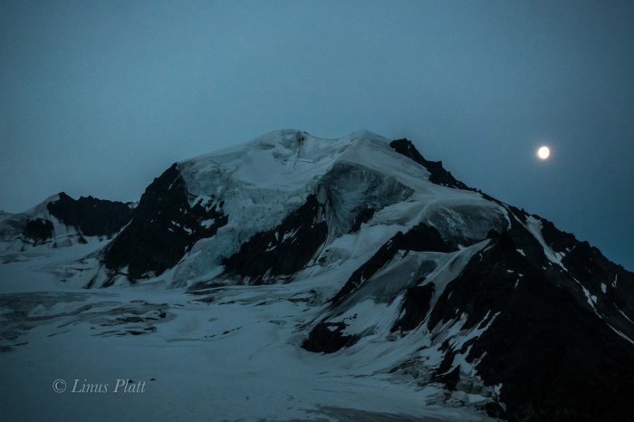
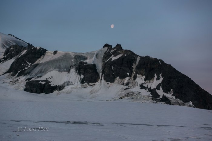
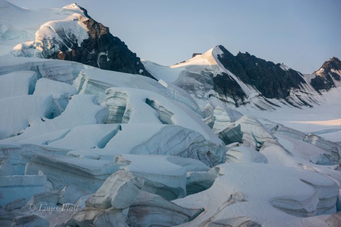
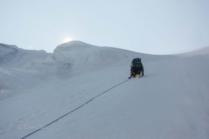
The alarm awakes me at 3 am to a perfectly still and silent Alaskan dawn. I peer from the tent and the delicate purple alpenglow splashes down upon this amazing cirque. The Deep blues of the seracs of the Moore Icefall with the crisp lavender skyline, the nearly full moon rising over Peak 7680, and the creaking of the glacier as it too slowly wakes, is an experience I will not soon forget. We are moving by 4 am and cramponing the perfect ice and neve towards the Moore Icefall, where it becomes clear some tricky route finding will be a necessity in order to bypass the many clusters of seracs and crevasses which block our way to the upper NW Face of Icefall Peak. Soon we are above the firn line and after sticking my leg through a snow bridge covering a menacing crevasse, we rope up and get to some proper glacier travel. Weaving in and out of the crevasses brings us to the first of several steeper seracs that must be negotiated and sometimes climbed directly. At the top of the first serac obstacle, a short bit of steep unprotected ice is climbed and the upper crevasse field is gained. From here we can see that there are more seracs and gaping holes to weave. At one point, just below the final steep bit before the final face, a crevasse appears so large I can hardly believe my eyes. It is the largest single crevasse I have ever seen. Perhaps 70 feet across and 200+ feet deep, it’s top covered by an enormous and fragile snow bridge that can only be seen from our side vantage. I am happy that it is not something we need to deal with and can simply enjoy witnessing it from our far away position. After crossing this monster it it’s terminus with the upper face, we climb a steeper section of snow and neve to the base of the final face. The weather is glorious and the seracs of Peak 7680 are shining brightly; the blue ice radiating the entire upper cirque – it is a lovely sight.
After a short lunch break, we untie the coils used for traveling the crevassed sections below us and decide to set up a belay and climb the full rope length. I lead upwards toward the upper wall which is steepening significantly. Beyond this headwall is the summit; I can see it. After a rope length, I come to the unexpected: unseen from below, there now sits before me a hidden crevasse barring passage to the headwall. It is maybe 25 feet across and 80 feet deep; the walls below me severely overhanging and rotten. I bring Dennis up and we attempt to traverse to the right in hopes of going around the gaping crack, but we are then blocked by another vertical fracture, essentially splitting the lower crevasse block in two. We must go down and down climbing ensues, bringing us back to from which we came. Time wasted, energy spent. Dennis is feeling exhausted and expresses his wish for me to make all the decisions from this point forward. Again I lead off to the right, this time from our lower position below the serac. I then climb upward to meet the giant and perplexing crevasse it it’s terminus with the steepening headwall to the right. I plant an ice screw and a snow picket and bring Dennis up. Above us looks difficult indeed; a step across the narrowest part of the crevasse leads to vertical water ice and rotten neve and leads to a rotting honeycombed ramp. I can see that the ramp leads squarely to the headwall and the summit, which looks to be only 200 feet away. This ramp is the key to the route. Breaking out my ice hammer for the first time on the route, I gingerly front point upward to the lip of the fracture and manage to just barely stem across to touch it’s far wall and place an ice screw. It feels bad… the ramp is skimmed with honeycombed ice and underneath is rotting neve which crumbles as I plant tools into it. I move up reluctantly and plant the hammer as high as I can but just can’t make it stick to my liking. My feet are underneath a slight overhang and I can’t see my front points. The only thing that is keeping me from breaking my neck on the lip of the lower wall is the shitty ice screw, now just below my feet. I come down. Then ponder… we are so gawdam close. I can practically spit to the summit. I go up again. Getting to the same spot, I feel the risk is not worth the potential disaster of falling off this face and I retreat. My attitude dissolves entirely and suddenly I am in a very bad mood. Dennis looks exhausted and expresses relief that we are not continuing. This makes my mood even worse. I gaze out over the growing shadows of the Moore Icefall and the hanging glacier on Peak 7680 and vow to myself to come back to this place to climb it. For now, all I wish for is to leave this cirque. I belay Dennis down to the base of the serac and after joining him, we begin the long and arduous decent through the jumbled maze of seracs and crevasses. After this is behind us, we are once again back on the lower angle part of the glacier just above the firn line where earlier, perfect crampon conditions made travel easy. Now, in the afternoon heat, the neve has turned to soft and vicious snow which must be post hole’d back down past the firn line to the bare ice, which is now flowing with water in the heat of the day.
We are back at the hut by 2 pm and I am feeling like packing up and walking out to the truck. Dennis does not wish for this and we decide that he will stay the night at the hut and I will walk out alone. I pack up the tent, and load my pack and am back on the ice by 3 o’clock. I tell Dennis that if he is not at the truck in 24 hours, I will come back to look for him. He agrees and we say goodbye and I begin the arduous 5 mile glacier walk to the tongue. The sights along the way are spectacular, but my exhaustion is taking it’s toll. At the tongue, I am faced with the previous decision of whether to go around the ice cave or to fjord the river. I am far too tired to climb the talus to go around, so I opt for the river. I find the shallowest section and stomp across. My boots are mostly soaked but not caring, I stagger the last couple of flat miles to the truck where I collapse and take off my sopping boots. A jump into the icy Phelan Creek makes me feel alive and clean, and soon the tent is set up and I am happily cooking supper and thinking about the next move. The next day, Dennis ambles in about 2 pm and we decide to head back to Delta Junction and re -group. In Delta that night the sunset on the Alaska Range impresses us and a deep sleep comes easily. The following morning, rain drives us into a diner for breakfast and coffee, where we talked of our next climb: The White Princess.


You must be logged in to post a comment.